Yes of course I can, and sorry, i know that when you press the button replace metadata and nothing happens…it can be a little annoying ;). So, it seems there is a problem with the lasts versions of the snap on this issue. Its a problem of the version. You can do the next:
Open on snap, the same product you exported to polsarpro.
import the bmp file (it must be the two products on the screen at left now.
Do a band math at the product you open first and CREATE a new band with the bmp image of the second product. It seems difficult on the band math operator, but you have to choose the another product. There is a way on the box options to select the another product ok!
With the new band on the original product (that is the bmp file), you can do whatever you want, also the terrain correction.
Faculdade de Ciências da Universidade de Lisboa
Campo Grande 1749-016 Lisboa · Portugal
T (+351) 217 500 000 * Ext. 28117 F (+351) 217 500 830
info@ciencias.ulisboa.pt
www.ciencias.ulisboa.pt
Hello! Do you know if its possible to do it using a graph?
I would like to do it in graph and then use the command line to run it.
I tried with a BandMerge but it didn work.
Thank you,
Mariela.
I’ve found your answer about “how to import PolSARpro output in S1 toolbox” very interesting. I’ve some questions:
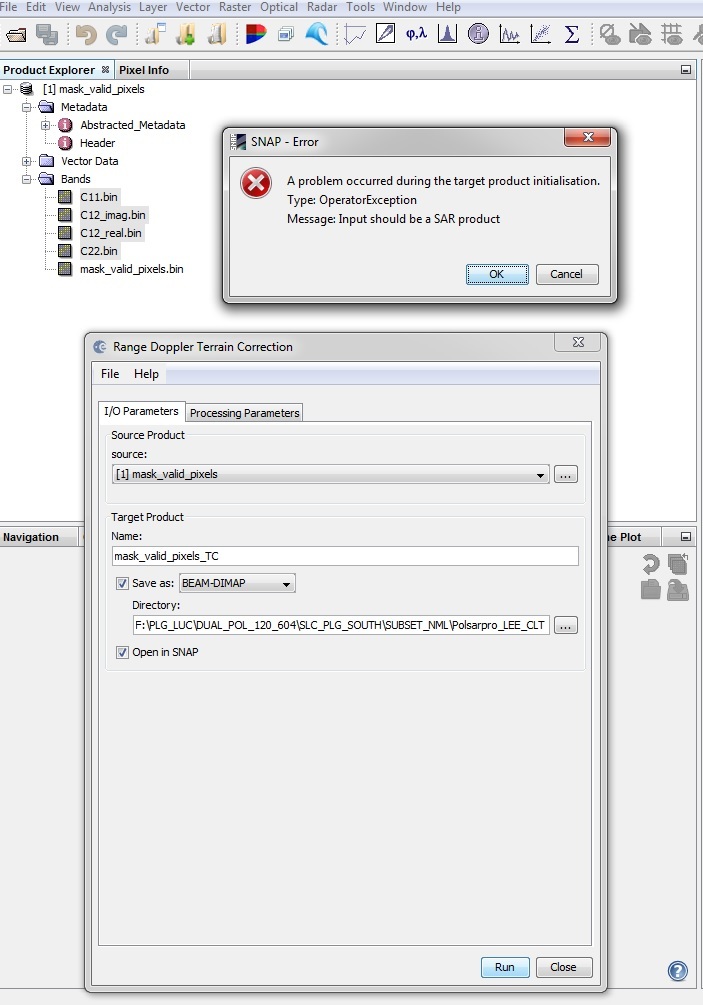
I’m using Sentinel 1 data (SLC dual polarization) and I’ve just worked out the C2 matrix with PolSARpro; than I’ve obtained the S.R.T.M. DEM. Now I need to do terrain correction using S1 toolbox.
Which file of the “C2 folder” shall I use in S1 toolbox?
Have you worked out the anisotropy after or before the terrain correction?
If you are importing a matrix from PolSARPro, just open one of the .hdr files. It will look at all files in the folder and treat it as one product.
However, if all you are doing is generating a C2 matrix, SNAP can do that automatically whenever you use a polarimetric operator on a dual pol SLC product or you could also use the polarimetric matrix generation operator.
SNAP also automatically downloads the SRTM tiles you need when terrain correcting.
PolsarPro drops all of the metadata. If you haven’t multilooked or changed the dimensions of the product, you can add the metadata from the original product back into your C2 product using Tools->Metadata -> Replace Metadata
Thank you so much for your help. I appreciate helpful solution from you. It works.
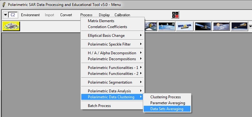
Actually the data which I applied the geocoding is obatined from “polarimetric data clustering > Data Sets averaging” using polsapro. Polsarpro automatically generated the RGB.bmp file. After geocoding in SNAP, I would like to create the same RGB file as polsarpro processing. Unfortunately, I don’t know the combination of R G B to create the bmp file using SNAP. Would you let me know for creating it?
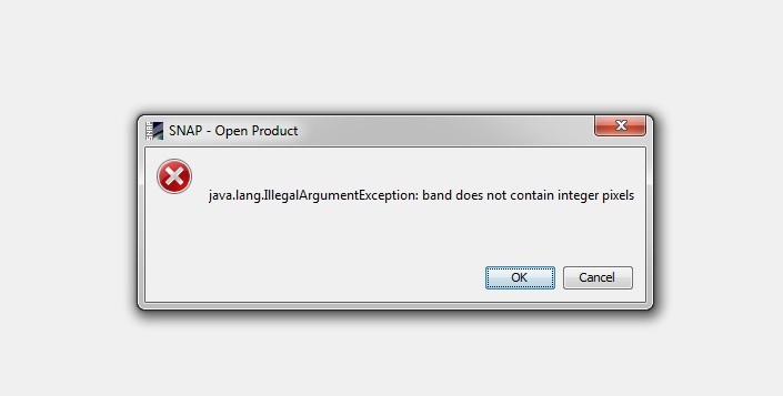
In PolSARpro the option of output data format is only “[C2]>>[C2}”. Sorry, I don’t understand the meaning of [C2]>>[C2]. Do you mean this output format integer?
the error message indicates that the data consists of float values (with decimals) instead of full numbers (integers). So I was wondering if this can be selected somehow in PolSARpro
Thanks aridane, it really worked for Sentinel 1 data.
But, what should be the PolType: for the C2 matrix that we have created from other data set, lets say a compact pol RH and RV
I, too, am having some problems with importing PolSAR Pro data formats into SNAP. When loading a binary file such as C11.bin.hdr, I get the following error:
Missing mandatory header key: data type
My .hdr file is as follows:
ENVI
description = {
PolSARpro File Imported to ENVI}
samples = 1565
lines = 1636
bands = 1
header offset = 0
file type = ENVI Standard
data type = 4
interleave = bsq
sensor type = UAVSAR
byte order = 0
map info = {Geographic Lat/Lon, 1, 1, -147.7007452, 67.09442268000001, 0.00011111, 5.556e-05, WGS-84}
band names = {
C11.bin }
As you can see, there is a “data type” attribute in the ENVI-formatted .hdr file. Is the .hdr file missing something, or am I?
Hi, I faced the same problem. The solution is to import .bin file as ENVI (File → Import → Generic Formats → ENVI).
Also, if anyone at some point of processing is doing Multilooking in PolSARPro and wants to work on this file in SNAP later, just perform Multilooking on a raw SAR image in SNAP too. Then use it as a source of Metadata for PolSARPro output (imported as ENVI). As a result, you’re getting the same shape of image as in PolSARPro. So:
Do whatever you want in PolSARPro + Multilooking.
Do Multilooking on SAR data in SNAP.
Import .bin file from PolSARPro to SNAP as ENVI data.
Replace metadata of .bin file (Tools → Metadata → Replace Metadata) for metadata of SNAP-Multilooking product (vide point 2).
(I’m writing this as I’ve noticed that in this topic there are presented solutions but for SAR data without Multilooking etc.)
