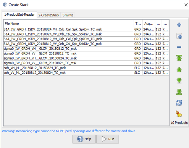
I am trying to co-register data that I am extracting from the Copernicus scihub, but I have not been successful for the simple reason that it seems the I have to first add geolocation to the chosen products so that they have the same coordinate system. Does anybody know how I can do this because I could not find a single decent documentation that explains how to accomplish this? And is there any formal documentation regarding SNAP, the use of geolocation and co-registration?
what kind of products do you want to coregister and why do you think geolocation has to be added?
Sounds quite complicated and maybe there is an easier way of doing it.
What kind of products are you using? A solution could be to reproject first to the same coordinate system (Raster–>Geometric Operations–>Reprojection) and later do the collocation (Raster–>Geometric Operations–>Collocation).
Thank you! Your solution did the trick as collocation is the feature that is utilised in SNAP to perform image registration.
Dear @abruescas, do oyu by any chance know what is the difference between collocation and coregistration in SNAP? Which one of these functions is actually performing image registration between two products?
let me try to summarize it:
- if you have only two datasets and both are well geocoded,
collocationis sufficient. - if you deal with multiple rasters and all are well geocoded, you can use
create stack. - if you deal with data acquired from different sources or angles or you have terrain-induced distortions (often the case for radar data) you need
coregistrationto match the rasters precisely at the sub-pixel level. This is also required for interferometric analyses
Please, anyone feel free to comment if I missed an important point.
@ABraun So in the third case, they won’t even be geocoded in the same manner? Do you have any tutorial which could kindly assist me in using the coregistration in snap correctly?
it depends a bit on the type of coregistration which is applied. The classic coregistration in SNAP takes data in slant range geometry as long as it has a similar looking angle (it cannot coregister ascending and descending pass radar images).
So it depends on the kind of data a bit which one is the most suitable. This is why I asked in my first answer.
Some are explained for different applications of Sentinel-1 but it is a special case because of the TOPS mode.All the following include coregistration:
- https://www.asf.alaska.edu/asf-tutorials/data-recipes/glacier-velocity-tracking/
- https://www.asf.alaska.edu/asf-tutorials/data-recipes/insar-using-sentinel-1-toolbox/
- http://step.esa.int/docs/tutorials/S1TBX%20Offset%20Tracking%20Tutorial.pdf
- http://step.esa.int/docs/tutorials/S1TBX%20Stripmap%20Interferometry%20with%20Sentinel-1%20Tutorial.pdf
- http://step.esa.int/docs/tutorials/S1TBX%20TOPSAR%20Interferometry%20with%20Sentinel-1%20Tutorial.pdf
@ABraun your answer is brilliant and invaluable to this community. Should give me a good head start. Right now I am trying to perform image registration between different satellite images as I am currently doing an MSC by research to try and improve image alignment performed by SNAP. I am first starting off with the same kind of satellite images such as Sentinel-1 data. Could the SNAP coregistration feature also be used for other satellite images other than sentinel-1 data? Say combine Landsat-8 to Sentinel-3 data?
I have doubts because of the large difference in spatial resolution.
Maybe the new coregistration is interesting to you in this context: GeFolki coregistration
Hi Andy,
I recently face up this problem, of can’t create databuffer, I surfed all the topics mentioned in here,
- Error when calibrating Sentinel 1 data “cannot construct data buffer”
- S1 TOPS Coregistration “Cannot Create Data Buffer”
- Java heap space / Data Buffer error when using gpt tool (terrain correction)
- Error: Cannot construct DataBuffer
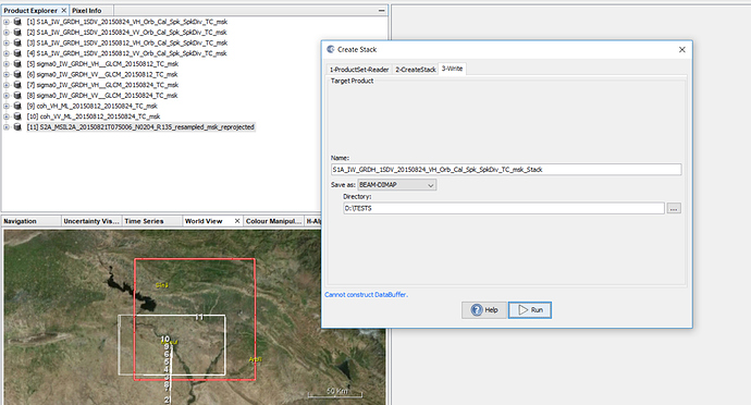
But I didn’t find solution, I tried up to create stack of the following layers, all of them are T.C. and they have EPSG:4326, the RAM of the machine is 16 GB, I increased the cache to 8000, firstly I have this warning, and the processing starting normally after 7% I got the error of cannot create data buffer, Any suggestions.
hmm, what kind of resampling did you select? I cannot imagine another process involved which requires a lot of memory.
In SNAP7 multi-product collocation will be possible, maybe this is an alternative then.
S2 image is resampled to 10 meter, and then reprojected to WGS84 , EPSG:4326,
The STACK is the first step of PCA, and then the RF_classification,
First question, When will be the final release?
Secondly, Do you mean multiple collocation could be applied instead of stacking towards PCA and RF_C?
I don’t know the exact date but it is supposed within the next days: https://forum.step.esa.int/t/snap-7-0-public-beta-nearing-release/15855/21
According to the release notes
many inputs will be featured so you can stack terrain corrected products (e.g. PCA and classification outcomes)

