I want to produce DEM in SNAP with ALOS-2 data,is there any document about DEM generation?
here is my method to generationDEM with alos-2:
(1) Calibrate
(2)coregistration
(3)speckle filter
(4)interferometry
(5)SNAPHU export
(6)Phase to Height
does my Process enough?please give me some advice
I personally would skip calibration because it only affects the backscatter intensity and has no effect on the phase information. Same applies for the speckle filtering.
Instead, you can perform the Goldstein phase filter after the inteferogram generation to get smoother results. Also you can compare the different outcomes of “phase to height” and “phase to elevation” (use the SRTM 1Sec here).
And remember: Coherence is key in this task. So any areas of temporal decorrelation will result in probably low elevation quality. It is thereferore always good to compute the coherence (included in the inteferogram step) and have a look at it.
1 Like
thank you very much ,I get alot from our reply,another tips,have you ever listen a method called PSP?
does deburst neccesary for alos2 to get DEM?
Debursting is only needed for Sentinel-1.
Can you give a reference to PSP?
sorry, I just listen from my workmate
is there any DEM generation steps doc in the forum
yours are correct (besides the filtering). An example for Sentinel-1 is given here: The Order of DEM Creating Steps
You can share screenshots of your interferogram and coherence in here if you want.
thanks a lot,where are you from ,can you share your twitter or Wechat with me
sorry, I don’t use these. You can simply copy and paste screenshots in the text fields.
when i interferometry in snap, an error occurs:
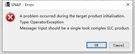
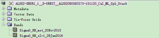
the file i input is:
single look = without multi-looking
complex = without calibration to Sigma0
As stated above, don’t use calibration and speckle filtering for interferometry.
Simply stack both SLC products with the Coregistration tool.
sogar thank you
do i need to remove topograph phase in my interferometry when produce dem
No. Topographic phase contains the information you want for DEM generation.
no topographic phase remove in DEM genaration?so many articels do this step ,why?
Can you please give an example?
Sometimes, the topographic phase is modeled, removed before unwrapping of what remains and later added again. This is said to improve the unwrapping.
Topographic phase is removed for differential interferometry, for example for the detection of subsidence between two images. For DEM generation, you are highly dependent from the variation of the phase which originates from topography. How else would you describe it then without it?
ok,when i reference to envi sarscape insar DEM workflow,reflatting is processed,this is used to remove flatting ,does this step equals to topographic phase removal?
Sorry for come into your discussion, but @zhuhaxixiong this is the simple equations to get displacement or to get the topography
