Yes, you need to avoid putting a reference point in one of the basins with active aquifer deformation. Other than that, it does not matter much, except that errors will increase with distance from the earthquake signal.
Thank you so much. In the paper published for the Geodetic Bayesian Inversion Software (GBIS), developers expressed “It is also recommended to remove a linear ramp of the form Z(x,y)=ax + by, where a and bare linear coefficients of the x and y coordinates, respectively, to account for any residual orbital error or very long wavelength atmospheric delay across the entire InSAR data set (e.g., Sudhaus & Jónsson, 2009). The parameters for a linear ramp across an entire image can then be estimated directly from the data during the inversion.”
Is this method (removing by calculating the linear ramp) applicable in all atmospheric conditions? I think we may be facing some uncertainties in areas where topography changes are high.
A linear ramp may not be effective at reducing atmospheric effects in all cases. It is only a first-order approximation. If you have atmospheric effects highly correlated with topography, then GACOS corrections might be effective.
1 Like
Thank you in advance for your suggestion. I will download them and read as soon as possible.
@EJFielding I found the following sentences in one of your papers, related to Mw=7.3 12 November 2017 Sarpol-e Zahab (Iran):
“The difference in the pattern of coseismic signals between ascending and descending geometry indicates that the mainshock did not have only pure vertical movement, but included also horizontal motion, which appears differently in ascending and descending data”
If I have the ascending and descending co-seismic maps with the same pattern, can I assume that there is no any horizontal displacement or ignorable horizontal displacement?
1 Like
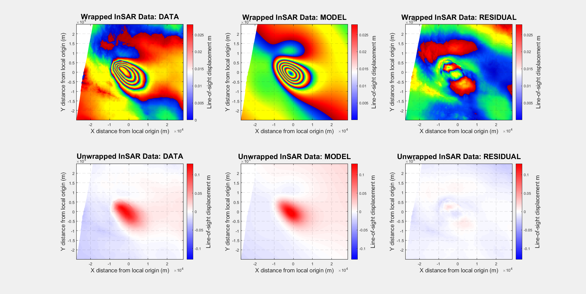
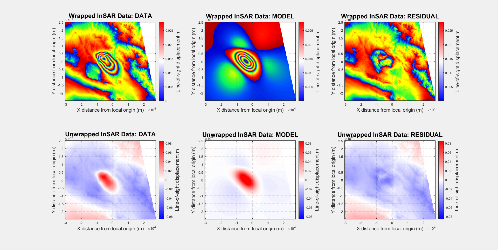
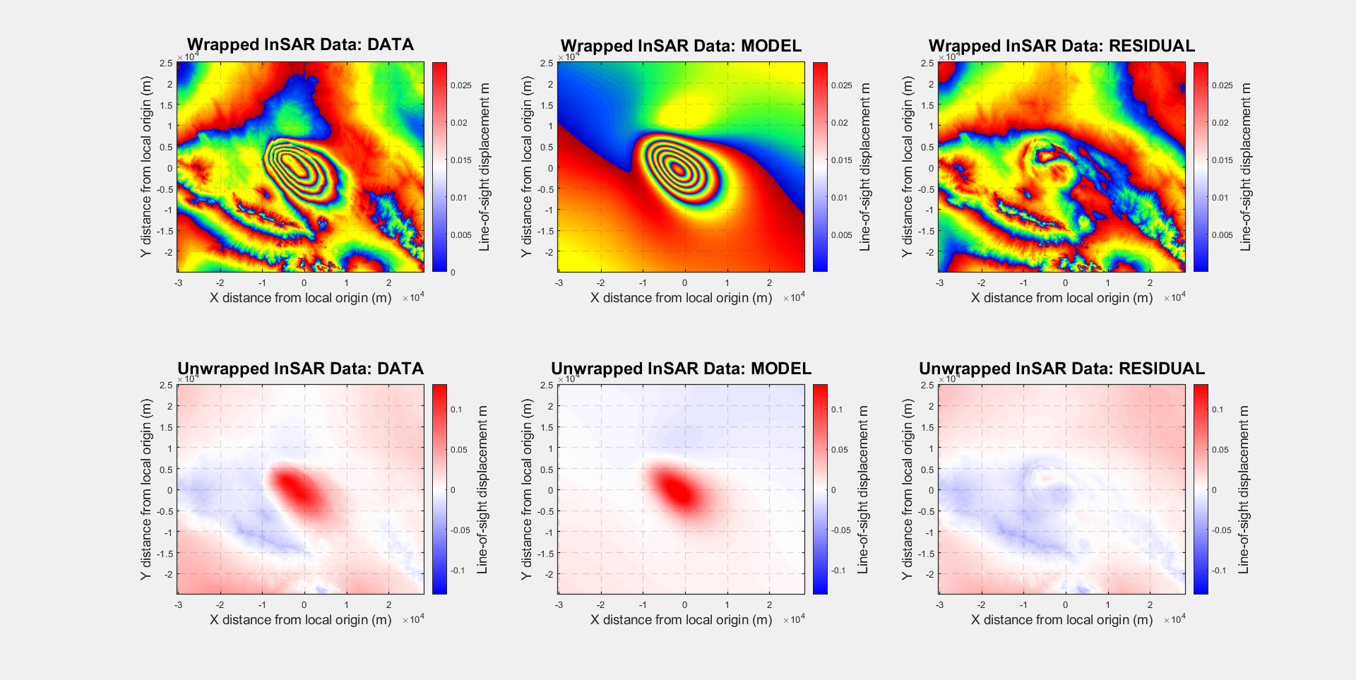
I would like to represent the results of modeling here. Based on the convergence figure of modeling progress, I am not completely sure about the accuracy of these results. I will be glad to have your comments:
Best regards,
3 Likes
Your model fits look good to me. Most of the residuals appear to be due to atmospheric effects.
1 Like
@EJFielding Thank you so much for your comment. I resampled my IFGs to 90 meters which is compatible with GACOS files and then, applied the atmospheric correction through GACOS. Now, I am just worried about the stability of solved model and achieved parameters so that the convergence plot of the used package is not as good as I expected.
Most remote sensing satellites measure the sun’s radiation reflected back from the ground, usually in the visible and infra-red part of the electromagnetic spectrum.
Hello!
I would like to know what methodology you used in producing the interferogram.
Thank you
Dear all,
Do you know how to set the burn-in index to generate a Final Report with GBIS? According to the software manual text, this represents the number of initial iterations to be excluded from the computation of subsequent density functions and other statistics. But I was testing with the number of iterations rejected by the software during the inversion and I get an error in the histogram function.
Best regards
Francisca
Hello, may I ask you how far you are in your research on po-SBAS?
Dear all,
I want to get horizontal and vertical displacements using this equation

I got the displacement (los) using a program SNAP and I want to compare my results with the horizontal and vertical displacements of points GPS, but I read in the forum that the resulting displacement LOS is relative. What should I do to make this comparison? Please help and thank you in advance
An urgent help message
, dear ones in this forum, please. I want to calculate the horizontal and vertical displacements resulting from the earthquake7.6 using the equation

.I calculate the LOS displacement using operator phase to displacement , and then applied the terrain correction. Isn’t this correct, or is this los displacement a relative displacement, and we must obtain a reference point in the study area with zero displacement to calculate the los displacements. Please help because I want to verify my results using GPS points. Thank you very much in advance
An urgent help message
, dear ones in this forum, please. I want to calculate the horizontal and vertical displacements resulting from the earthquake7.6 using the equation
.I calculate the LOS displacement using operator phase to displacement , and then applied the terrain correction. Isn’t this correct, or is this los displacement a relative displacement, and we must obtain a reference point in the study area with zero displacement to calculate the los displacements. Please help because I want to verify my results using GPS points. Thank you very much in advance
@ABraun @EJFielding @SMJ.Mirzadeh
InSAR measurements are always relative. In addition, you can only use that kind of combination equation if the ascending and descending track have the same reference point set to zero.
1 Like
thank you very much for reply
Is there a way to help me set the reference point (the reference point must be the value of los displacement in the ascending and descending orbit equal to zero), Another question please, even when using InSAR to produce Dem , I cannot compare result Dem with field measurements because measurements are relative and a reference point must be specified
@EJFielding thank you very much for reply
Is there a way to help me set the reference point (the reference point must be the value of los displacement in the ascending and descending orbit equal to zero), Another question please, even when using InSAR to produce Dem , I cannot compare result Dem with field measurements because measurements are relative and a reference point must be specified
To make an InSAR DEM, you need to use a reference point where you know the elevation from some other source. For InSAR displacement maps, you can either find a reference location where you know or assume the displacement is zero or use a point where there is a GPS station that has a measured velocity.
1 Like
@EJFielding Thank you very much for your kindness and reply. I have Two GPS stations in my area where the horizontal and vertical displacement values are known due to the earthquake. I want to compare the displacement values that I obtained using DInSAR with the measured values for these two stations. . Should I assume a reference point(LOS displacement is zero) in the study area close to GPS stations . Subtract its LOS displacement value from the LOS displacement maps in the ascending and descending orbit, then apply the equations to obtain the absolute horizontal and vertical displacements? Or, after obtaining the horizontal and vertical maps, I can assume a point with zero displacement and subtract the value of its horizontal and vertical displacement from the horizontal and vertical displacement maps