Hi
We recently discovered that for some cases, the coastline location in products processed from different RON’s can be significantly different, approximately 60 m in North-South direction. Only when processing data from SLC, using GRD directly looks good.
When looking further, it turned out that the location error is dependent on the size of the processed area: it is bigger when processing the whole sub-swath, but very small or non existent when processing a single burst. In our initial case, both RON’s cover the coastline on the end of swath (burst 8 and 9), so they both have errors on the opposite directions and single product error is not 60m, but half of it.
I have tried SNAP8 and SNAP9, SRTM and Copernicus DEM’s and while the choice of DEM changes the outcome, it is not related to particular location issue.
I have tried to keep the processing as simple as possible. To reproduce the problem, just process the following graph with $burstStart, $burstEnd value choices of 1,9 and 9,9 with input file “S1A_IW_SLC__1SDV_20220430T160451_20220430T160518_043005_052272_1CB6.SAFE.zip” and visualize parts of coastline.
Possibly related topic Range-Doppler Terrain Correction raster size and coordinates inconsistency
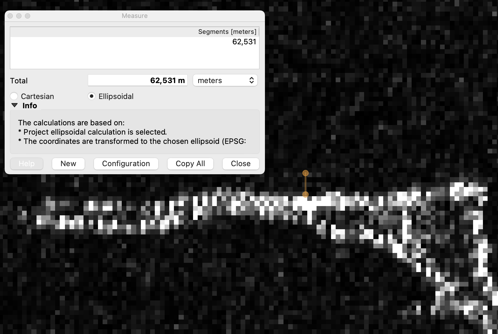
In the following screenshots, the brown measurement line is geographically in the same position, data is from two different RON’s, showing the maximum relative difference.

Best regards
Andres Luhamaa
<graph id="Graph">
<version>1.0</version>
<node id="TOPSAR-Split">
<operator>TOPSAR-Split</operator>
<sources>
<sourceProduct>$sourceProducts</sourceProduct>
</sources>
<parameters class="com.bc.ceres.binding.dom.XppDomElement">
<subswath>IW3</subswath>
<selectedPolarisations>VH</selectedPolarisations>
<firstBurstIndex>$burstStart</firstBurstIndex>
<lastBurstIndex>$burstEnd</lastBurstIndex>
<wktAoi/>
</parameters>
</node>
<node id="TOPSAR-Deburst">
<operator>TOPSAR-Deburst</operator>
<sources>
<sourceProduct refid="TOPSAR-Split"/>
</sources>
<parameters class="com.bc.ceres.binding.dom.XppDomElement">
<selectedPolarisations/>
</parameters>
</node>
<node id="Terrain-Correction">
<operator>Terrain-Correction</operator>
<sources>
<sourceProduct refid="TOPSAR-Deburst"/>
</sources>
<parameters class="com.bc.ceres.binding.dom.XppDomElement">
<sourceBands>Intensity_IW3_VH</sourceBands>
<demName>SRTM 3Sec</demName>
<externalDEMFile/>
<externalDEMNoDataValue>0.0</externalDEMNoDataValue>
<externalDEMApplyEGM>true</externalDEMApplyEGM>
<demResamplingMethod>BILINEAR_INTERPOLATION</demResamplingMethod>
<imgResamplingMethod>BILINEAR_INTERPOLATION</imgResamplingMethod>
<pixelSpacingInMeter>13.84</pixelSpacingInMeter>
<pixelSpacingInDegree>1.2432683532214177E-4</pixelSpacingInDegree>
<mapProjection>GEOGCS["WGS84(DD)",
DATUM["WGS84",
SPHEROID["WGS84", 6378137.0, 298.257223563]],
PRIMEM["Greenwich", 0.0],
UNIT["degree", 0.017453292519943295],
AXIS["Geodetic longitude", EAST],
AXIS["Geodetic latitude", NORTH]]</mapProjection>
<alignToStandardGrid>true</alignToStandardGrid>
<standardGridOriginX>0.0</standardGridOriginX>
<standardGridOriginY>0.0</standardGridOriginY>
<nodataValueAtSea>false</nodataValueAtSea>
<saveDEM>false</saveDEM>
<saveLatLon>false</saveLatLon>
<saveIncidenceAngleFromEllipsoid>false</saveIncidenceAngleFromEllipsoid>
<saveLocalIncidenceAngle>false</saveLocalIncidenceAngle>
<saveProjectedLocalIncidenceAngle>false</saveProjectedLocalIncidenceAngle>
<saveSelectedSourceBand>true</saveSelectedSourceBand>
<saveLayoverShadowMask>false</saveLayoverShadowMask>
<applyRadiometricNormalization>false</applyRadiometricNormalization>
<saveSigmaNought>false</saveSigmaNought>
<saveGammaNought>false</saveGammaNought>
<saveBetaNought>false</saveBetaNought>
<incidenceAngleForSigma0>Use projected local incidence angle from DEM</incidenceAngleForSigma0>
<incidenceAngleForGamma0>Use projected local incidence angle from DEM</incidenceAngleForGamma0>
<auxFile>Latest Auxiliary File</auxFile>
<externalAuxFile/>
</parameters>
</node>
<node id="Write">
<operator>Write</operator>
<sources>
<sourceProduct refid="Terrain-Correction"/>
</sources>
<parameters class="com.bc.ceres.binding.dom.XppDomElement">
<file>$outfile</file>
<formatName>GeoTIFF</formatName>
</parameters>
</node>
</graph>