Getting image with some missing pixels

hello everyone,
I want to do a wetness index transformation on band math with the following formula,

Previously I already trying a wetness index transformation with this formula and got good results.

but when I did it again in a different year or different screen time there were some missing pixels at the image

Any advice on this?
Your help is much appreciated!

Sasa

Dear Sasa,

Thanks a lot for your message, https://forum.step.esa.int/t/missing-some-pixel-after-band-math/36163

However, I highly recommend you to use the public forum always instead,

Coming back to your question,

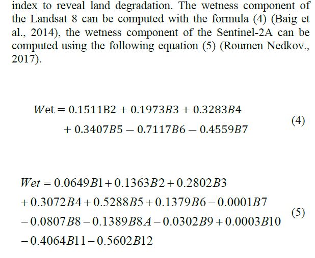
First, As I understood from your shared screenshots, you’re using Landsat_8, for this reason I think there’s better and easier formula to calculate wetness index, which is,

image
j.rse.2017.12.012.pdf (2.7 MB)

Second, Important notes should be taken in your account whether using the formula I shared or yours,

A. For missing pixels , check up the resample method you followed, and before hand check up the original image!,

B. I think there’re many other parameters play substantial role in calculating the wetness index the vegetation, water content, and others, because most of the missing pixels within sea and onshore or coastal line area.

Mapping Crop Residue by Combining Landsat and WorldView-3 Satellite Imagery

My last piece of advice, Use closest day to the one you faced up missing pixel and try it out.

I hope the foregoing meets your demand!

1 Like

Thank you for the reply.
i am sorry, i mean the wetness in this topic is the wetness with formula (5)

MONITORING AND ASSESSMENT OF ECOLOGICAL CHANGE IN COASTAL CITIES BASED ON RSEI.pdf (3.7 MB)

to prosessing the wetness im using Sentinel 2 (S2A_MSIL2A_20210730T024551_N0301_R132_T49MCN_20210730T070754.SAFE)

Thank you so much for the advice
I think the problem is with band10, because band10 can’t be corrected in the sen2cor plug-in, so I’m sampling that band in Arc.Map. then do layer stacking to be processed in snap band math.

I am also trying to process the wetness in an Arc.Map but the result value is high different with the value that I process in a snap

I was trying to find the closest day to the product that i used, but unfortunately in tropical latitudes it’s a bit difficult to find cloud-free images :sob:

Finally i got the solution. Thank you Professor Fakhri (^▽^)

Dear Sasa,

Sorry that I didn’t follow this topic up, but this answer for you and any one of the future folks,

According to your image convention name, you don’t need to apply sen2cor, because your tile is already a Level-2A is already corrected from Top Of Atmosphere (TOA) to the Bottom Of Atmosphere (BOA) reflectance product.

Please have a look at purpose of sen2cor,

Sen2Cor for Sentinel-2