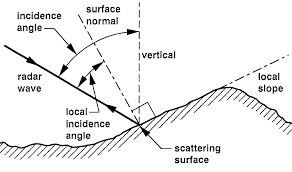
I looked up the topic about the incident Angle of Sentinel-1, and found that the incident Angle of Sentinel-1 images is a range.
How to normalize the incidence Angle of Sentinel-1?
the easiest way to perform incidence angle normalization is to apply radiometric calibration (output to Beta0), followed by radiometric terrain flattening. This will reduce the variations in backscatter caused by both global and local incidence angle as presented here: Small (2011) Flattening Gamma: Radiometric terrain Correction for SAR imagery.
Thank you for your reply,
This way is that you mentioned in here?https://forum.step.esa.int/t/normalize-incidence-angle/8016/2
Range Doppler Terrain Correction can output three angles: Incidence Angle from ellipsoid, local Incidence Angle, projected local Incidence Angle.Which represents the incidence angle?

What is the difference between this method and the method of calculating the angle of incidence you proposed here? https://forum.step.esa.int/t/about-processing-radiometric-calibration-iw-slc-in-snap/3641/18
The
The local incidence is not a perfect measure for normalization, so the terrain flattening is way more precise because it estimates the area illuminated by the sensor based on its slope and orientation to normalize the backscattered energy. Terrain Flattening Operator - #4 by eyeinsky
Plus it is implemented in SNAP.
So should I apply radiometric calibration and radiometric terrain flattening to normalize the incident Angle?
Then in the Range Doppler Terrain Correction, which angle should I output to represent the incident angle.
yes, these steps already make use of all information on the acquisition geometry. You don’t need to specify any further output (e.g. the angle) in the Range Doppler Terrain Correction because the data is already normalized in the previous step. If you still want to see how the local incidence angle looks like you can optionally check to include the projected one in the target product. But technically you don’t need it any longer, Range Doppler Terrain Correction is a purely geometric correction while Calibration and Terrain Flattening are steps for radiometric correction.