hi
Please bear with me, as I am a new user with SAR data, and in some my post the answers haven’t been really clear to me.
I doing a project determing vertical displacements using 2 S1A images using instruction “Sentinel-1 TOPS Interferometry”-Michael Foumelis.
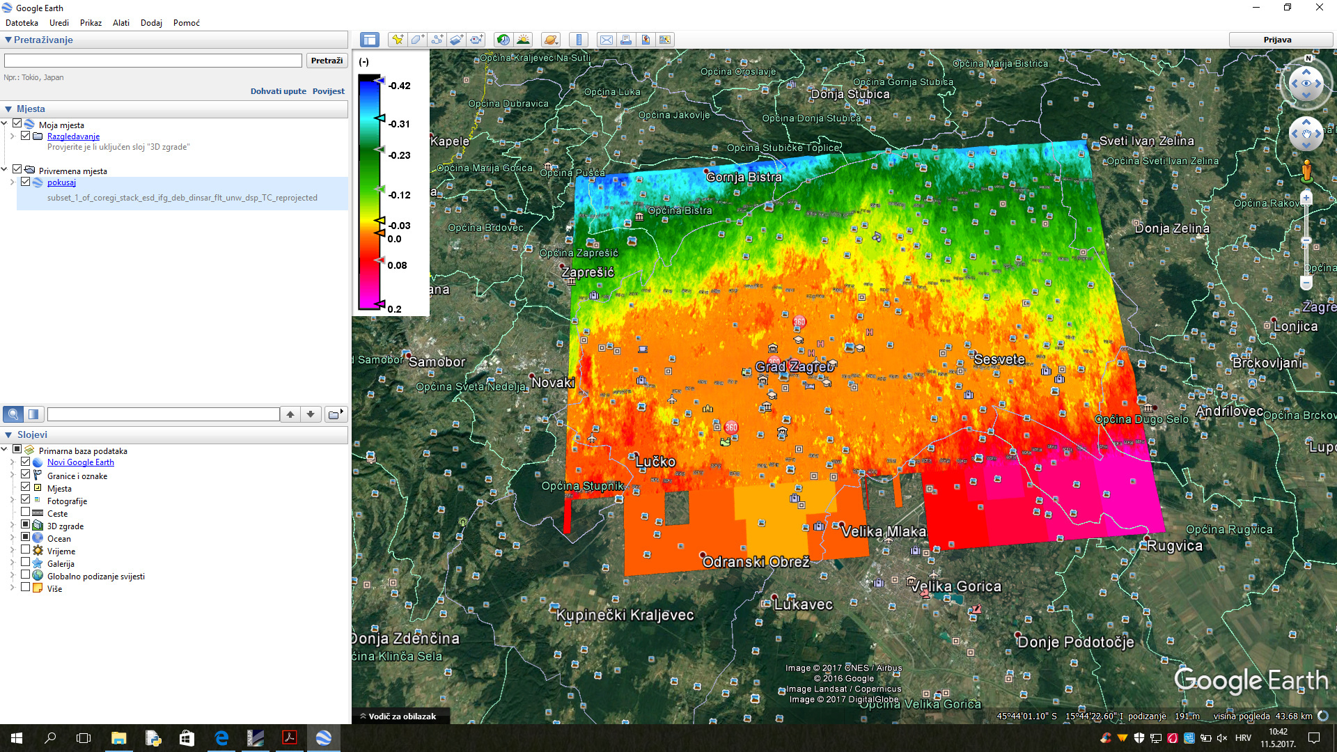
I found a problem with values of displacement because when I export result in .kml file and open it in Google Earth application I see that values of displacement have correlation with values of terrain height. I don’t understand how it can be correlated because in processing I do “Topographic fase removal” step which should remove topographic influence on values of displacement.
Can anybody please help me to solve this problem? Thanks
thi is screenshot from Google Earth application.
I’m doing processing for area of Zagreb city (Croatia). On the image the orange and yellow part represents centre of city and it’ neighborhood and for that area values of displacement are good. Green and blue part of picture represents area of mountain Medvednica (max height 1033 m) and you can se that from going to north values of displacement get bigger and bigger??
this kind of ‘ramping’ is often observed in Sentinel-1 repeat pass interferometry. It is probably caused by insufficient topographic phase removal but also from atmospheric effects.
Was your coherence good in your image? You could mask out areas with coherence lower than 0.3 for example. The resulting pixels could contain higher information content.
How large is the temporal gap between both images?
Temporal gap between images is 16 months (First image:20151022, Second image 20170213).
Can you please describe me how can I mas out areas with coherence lower than 0.3?
Of course you need the long temporal baseline in order to observe changes. But the coherence won’t be high over the full image.
Regarding the atmospheric content: Maybe you have the chance to investigate another image pair within a similar period. If it contains the same ramping as your example above, it is probably caused by the topographic phase removal (did you use the 1Arc Sec SRTM instead of the 3Sec?). If it is different atmospheric effects dominate in the distortion of your displacement values and you could have more success with another image pair.
I’m stil trying.
If I understood, I need to mask out unwrapped phase which I get after interferogram formation?
can you please suggest me what value of coherence I should put in coh_VV_22Oct2015_13Feb2017 > ??
Sorry but I don’t understand
I get unwrapped phase after using SNAPHU module in virtual box what is about on the half way of processing, and Interferogram formation is third step in processing immediately after Radar > Coregistration > S1 TOPS Coregistration > S1 TOPS Coregistration. So do I need mask out pixels after on the begining after I ger Interferogram formation, or I need to mask out pixels after unwrapped phase??
after unwrapping or at the very end. It is just to exclude the pixels in the final product with low coherence. So you could also do it after terrain correction.
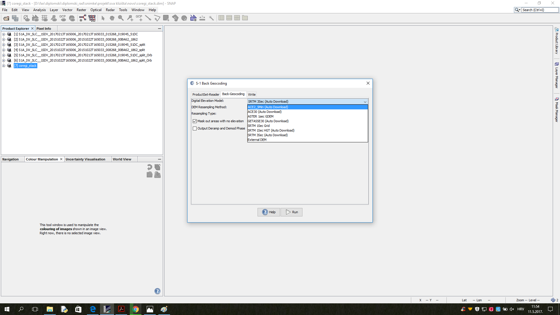
I already have this instructions and I did import by these steps, but my problem is that I cant’t see on page 36 what is the name of 1-Read-phase folder???

 Here is all what I can use