Please bear with me, as I am a new user with SAR data, and in some my post the answers haven’t been really clear to me.
I am trying to do Intensity and Coherence correlation analysis between 2 S1A-IW images with dual Polarizartion VV-VH. I have followed the tutorial S1TBX TOPSAR Interferometry. This tutorial however, does not perform geometric calibration, radiometric calibration or multilooking analysis and works with single polarised images.
I have the following question which I hope you can help me answer:
Do I need to perform calibration, radiometric and multi-looking analysis. And if so, where in the workflow.
For multi-looking analysis which ratio should I use? I have images of 5m *20 m resolution and the concept of multilooking is not very clear for me.
Which polarization should I use as I have 2 per sub-swath VV or VH? Is there any difference?
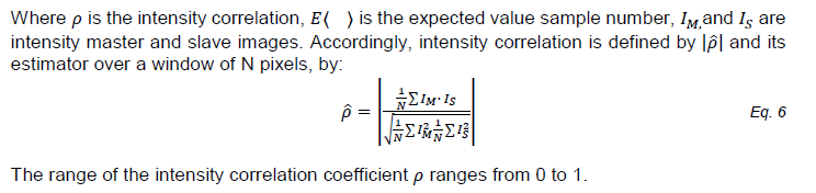
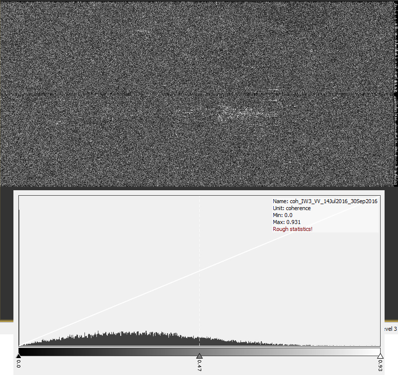
I have seen that the final result of the Interferometric process produces 3 bands, Phase, Intensity and Coherence. For the coherence correlation I believe is very straight forward and the values range from 0-1 as expected. I need to run this estimation using different windows sizes and I believe is possible. I just want to know if my line of thinking is correct here.
I have a formula for intensity correlation which I have attached as an image to this treat. The intensity band on the final interferometric process however leads to huge values and I dont know what I need to do to get values that range from 0-1 or how to apply the steps of the formula.
I wish you can help me out. Please take a look at the image for the formula.
If you are trying to compare intensities then you should calibrate first.
Multilooking is just averaging over a window. The ratio is intended to give you square pixels on the ground. The resolution will be reduced by the number of looks.
The polarizations can provide you different information about how the signal interacts with objects on the ground.
Thank you.
I reckon then I need to do this at the beginning (radiometric and geometric calibration), and then do the Interferometric analysis. Where in the the workflow can I do the multi-looking, and will this be 4:1 to get a 20m by 20m?
About polarization, then a vertical-vertical is “better”? than a VH? I tried to read on this topic but it got too difficult too fast when they started introducing formulas.
Calibrate first and then coregister.
Why do you need to multilook? For the intensity analysis, you may want to speckle filter and then do your analysis. You can then apply your geometric corrections (terrain correction) last to produce your map.
Co-pol (VV) should give you better coherence than cross-pol (VH).
@Iveci:
That is really good information. I don’t really know why I need to multilook. In different essays I have read that people multi-look in order to get squared-like pixes and I also know that the resolution decreases.
I believe they do this in order to apply square windows when doing the intensity correlation analysis, using different square widows sizes 5x5, 7x7,9x9… but i guess this analysis can also be done with NXM windows, however seems to me that multi-looking is appropiate.
When I have my individual images (corrected), then how can I apply my formula? by using the math operators? or is there a straight forward way.
Unfortunately, the band maths cannot be applied to a window. It only works on a pixel by pixel basis.
You would need to use the Java or Python API to program it or export to GeoTiff and do it in Matlab.
If you have a stack of intensity products (not complex) and use the coherence operator, it will apply something similar for amplitude change detection.
@Iveci:
That is another question I have, when you say “Not complex”. The images as raw data have information in COMPLEX format right? and the intensity band is already the amplitude^2 right? Do I need to do something to convert data to “Not complex”…
For the Intensity analysis I will try to use matlab or perhaps ERDAS Image.
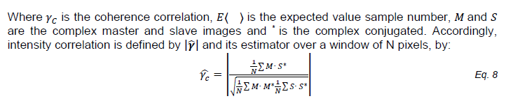
And one last quation, the coherence estimation band that i get from the interferometric process, already gives the the coherence correlation coefficient right? Do you know if this estimation is calculated with the following formula?
Hello,
I’m also a beginner in InSAR,
I would building a DEM using Sentinel-1 data and SNAP.
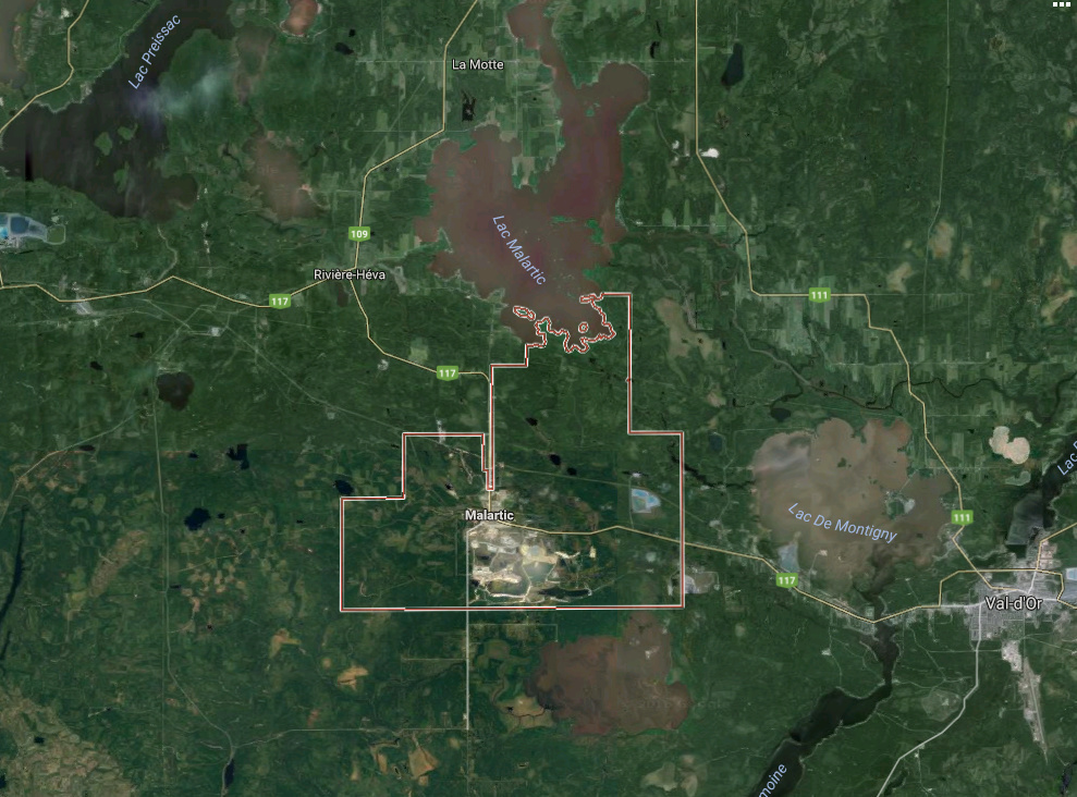
In addition to my limited experience in this field, my study site seems to be difficult because of the forest (Canada, fig.1).
In reality, no radiometric / geometric correction is made before co-registration. Suggestions???
What I can do as calibration / correction to improve coherence.
You image pairs are from July 14 and Sept 30. You could start by reducing the time between acquisitions. Try a 6 day difference with S1A and S1B pairs.
I want to do an Intensity correlation comparison between images. I am running my calibration process for my AOI to get normalised backscattering coefficients. I am producing sigma, beta and gamma, however I am not really sure which product is the best to at the end.
If someone can give me some information on the differences of this products… (I know is related to the area of normalisation), however this isn’t very clear for me. And also, is there a way to assess the calibration?
Hello DanielPL. Usually, SAR people would like to use sigma_naught, which means the back-scattering coefficient per unit area in slant-range coordination(of course before geocoding process). In terms of beta and gamma, I am not quite sure about which one is back-scattering coefficient per unit area in ground-range coordination and which one is back-scattering coefficient per unit angle.
Note: Sigma0 refers to the illuminated area in ground-range on the ellipsoid. If there is significant topography terrain flattening should be the best choice.
This is actually true, the formulas are exactly the same but with no complex data, or complex conjugates
I haven’t reach this part yet, as I am spliting and calibrating my images first. If i am working with calibrated data , do you rhin the coherence estimator with work?
Anyway, I have another question:
I have images from the 03,15,27 of August. Do you recommend speckle filter or multi-temporal filtering?.. The image of the 27 is not exactly the same as 03 or 15, just a small part in the IW3 overlaps with the IW3 of the other 2 images (“but covers my area of interest”)
Hello, thank you for your answer.
So. I want to do intentisy correlation analysis. I have 3 images IW with dual polarization VV-VH and apparently I did something wrong because now, after calibration I cant coregister.
I split the image as I only need the IW3 burst…(Apparently I should not have done that). I have to calibrate the whole image right.
So, do I need to select only sigma, or also complex result… I just want to make sure that after calibration i can perform co-registration. And also… when should I do terrain flattening or geometric correction and noise filtering?
@Iveci… please help. I dunno what I am doing wrong.
I need to do the intensity correlation but after calibration I CANNOT coregister.
I have S1A IW images with VV-VH polarization this means I have 6 bands (each one with i,q and Intensity). I really only need the IW3_VV. I tried to split the images to only use this band however for corregistration it said I needed all the bands and all polarizations.
I did the calibration and selected both polarizations and now I have basically the same images, but the intensity band has backscattered values, However I cant still do registration as the step TOPS-Split does not detects the bands… I really dont know how to do the process anymore…
Please some insight on how to calibrare when I have VV-VH IW1 IW2 IW3 and then how to co-register.
If you only want the intensities: apply orbit correction, calibrate, deburst and then use DEM Assisted coregistration or Cross Correlation Coregistration.
If you want the complex values for complex coherence: apply orbit correction, calibrate with complex output, TOPS Split, TOPS coregistration, coherence, deburst.
In order to accelerate the process, can I Split the IW3 since the beginning? Specially for complex coherence, will the TOPS-corregistration, will let me do this? Or should I work with all bands at all times.
*** Sorry for double posting, I dont know what I was doing there.
Let me explain the different steps that I have followed to work with intensities. (2 images one from 08/15 and one 08/27 20016)
As you suggested, I did the following:
Slip to only get the IW3 _VV
Apply Orbit Correction
Calibrate to obtain only sigma band
Debust
Coregistration. This is the part that I have some questions.
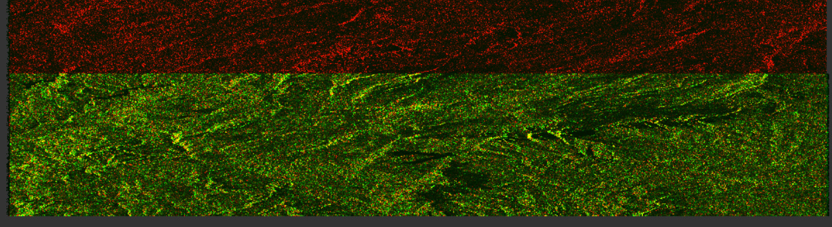
First I did a test using the DEM Assisted Coregistration using the sigma band of both my images. An this is the image I get in RGB visualization:
Then I did a Cross Correlation Coregistration with the default parameters of coarse registration and .001 RMS treshold. I believe that I cannot apply fine registration as the data is not comples, am I right? This is the image I get.
The red dots are just an area that doesnt overlap between the 2 images, which is not important as my AOI is not here.
For the CrossCorrelation I was able to get the residuals, which I believe are too big. Please take a look at this image
I believe the values are too high? Or please let me know which values should I be expecting? and How can I assess the coregistration using DEM Assisted.