@mdelgado @ABraun @thho @CFEgildan71
I have re installed os again and run the stamp and still am unable to get the result


As it remained unanswered so far: Do the folders you have exported from SNAP look alright?
- geo
- rslc
- diff0
- dem
Their content should look similar as here: Workflow between SNAP and StaMPS
thank you for reporting.
@ABraun stay blessed!
Well…
could it be related to the gcc version employed?
Which one you used to compile the code in the stamps/src folder?
@Am not quite sure whether it is related or not…
I found it on CentOS … so this is why I am asking.
@now am simply runing default stamp(1,1) without any command
in which step i should have to insert?
setparm(‘insar_processor’,‘gamma’)
and
setparm(‘scla_deramp’, ‘y’)
you can set the parameters in the beginning and they apply whenever the corresponding step uses them
Please have a look at this great documentation of all parameters: https://gitlab.com/Rexthor/gis-blog/-/blob/master/StaMPS/2-4_StaMPS-steps.md
Setting the processor to “gamma” does not make sense to me when you prepared the data in SNAP.
@ABraun I have already processsed up to step2 is it needed to go back or inserting the parameter at step 3?
whenever you change a parameter, you have to reprocess all steps which included it.
You can check in the source code where each parameter is used: https://github.com/dbekaert/StaMPS/blob/master/matlab/stamps.m
as you see in line 121, insar_processor is used in step 1, so if you want to go sure that changes will correctly be applied, you have to run again from step 1.
test_result!
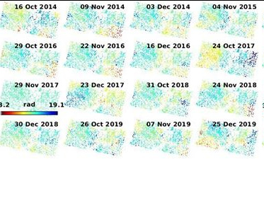
very good, congratulations on getting through the technical part!
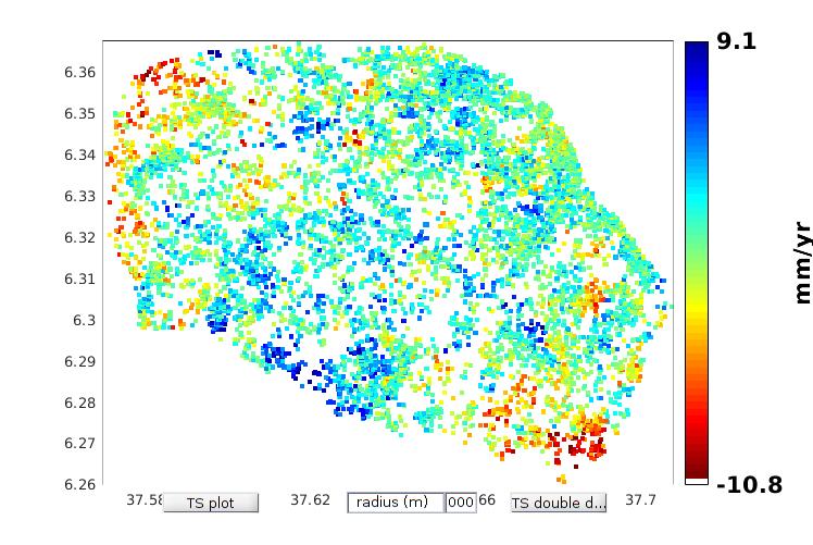
Thanks alot @ABraun… this is the area with out subseting the study area…is there anyway to subset the map in matlab or other mapping softwares?..and i need the result to be in mm/year rather than rad/year what i have to do?
you can define a subset of the created map as described in the manual:
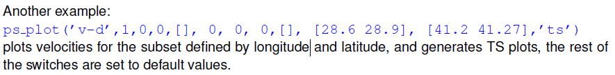
please check the plotting options. You need ps_pot('v-do') for metric results.
@ABraun ps_plot(‘v-d’,1,0,0,[], 0, 0, 0,[], [6.174 6.369], [37.37 38.201],‘ts’)
am not able to subset using this command-line ?
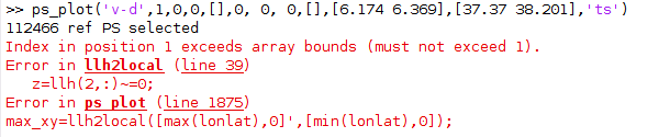
The error refers to your coordinates. Did you enter the longitudes in the first bracket and the latutudes in the second?
Because when I enter the coordinates of your example, I end up in Switzerland, not Indonesia. Try switching the coordinates.
You get the full documentation of all variables at the positions here: https://github.com/dbekaert/StaMPS/blob/master/matlab/ps_plot.m#L2
solved…