Hi guys,I have four image 2016 till 2019,
I wanna split them ,they should be splited in one subswath but for example in iw1 subswath my wanted area can’t be splitd in images in iw2,iw3 subswathes it’s this way too,
How I can split my wanted area in same subswath?

you are using images of different tracks (=relative orbits)
If you want to have the area covered by the same sub-swath, you have to make sure that all of your images are acquired within the same track…
So, what shall I do
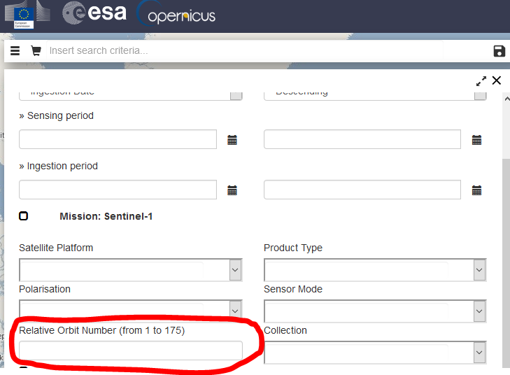
In relieve orbit number what number should i type till I can split images in same subswathes?
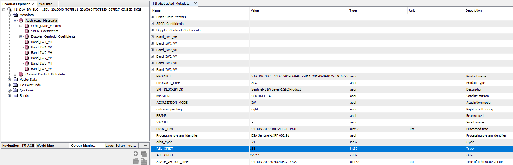
you can check the metadata of your products which track they belong to:
Search for REL_ORBIT (under Abstracted Metadata)
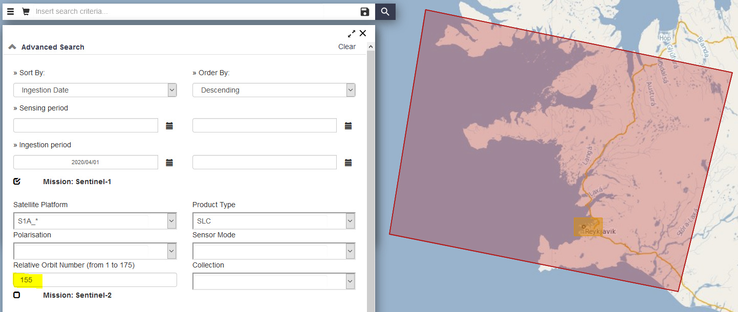
Then only download and use images of the same relative orbit.
In my case, I would search for images belonging to track 155
In your case, you have used images of different tracks which do not have the same geometry at the ground and, accordigly, different sub-swaths
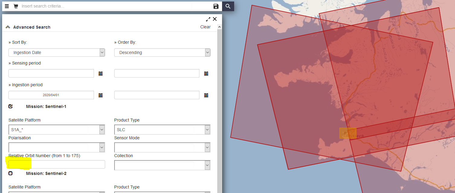
Ok thank you so much,what does RALTİVE ORBİT NUMBER depends of ?
the relative orbit (=track) is the path which a Sentinel-1 satellite revisits all 12 days.
https://sentinel.esa.int/web/sentinel/missions/sentinel-1/observation-scenario/acquisition-segments
https://sentinel.esa.int/web/sentinel/missions/sentinel-1/satellite-description/orbit
Another question
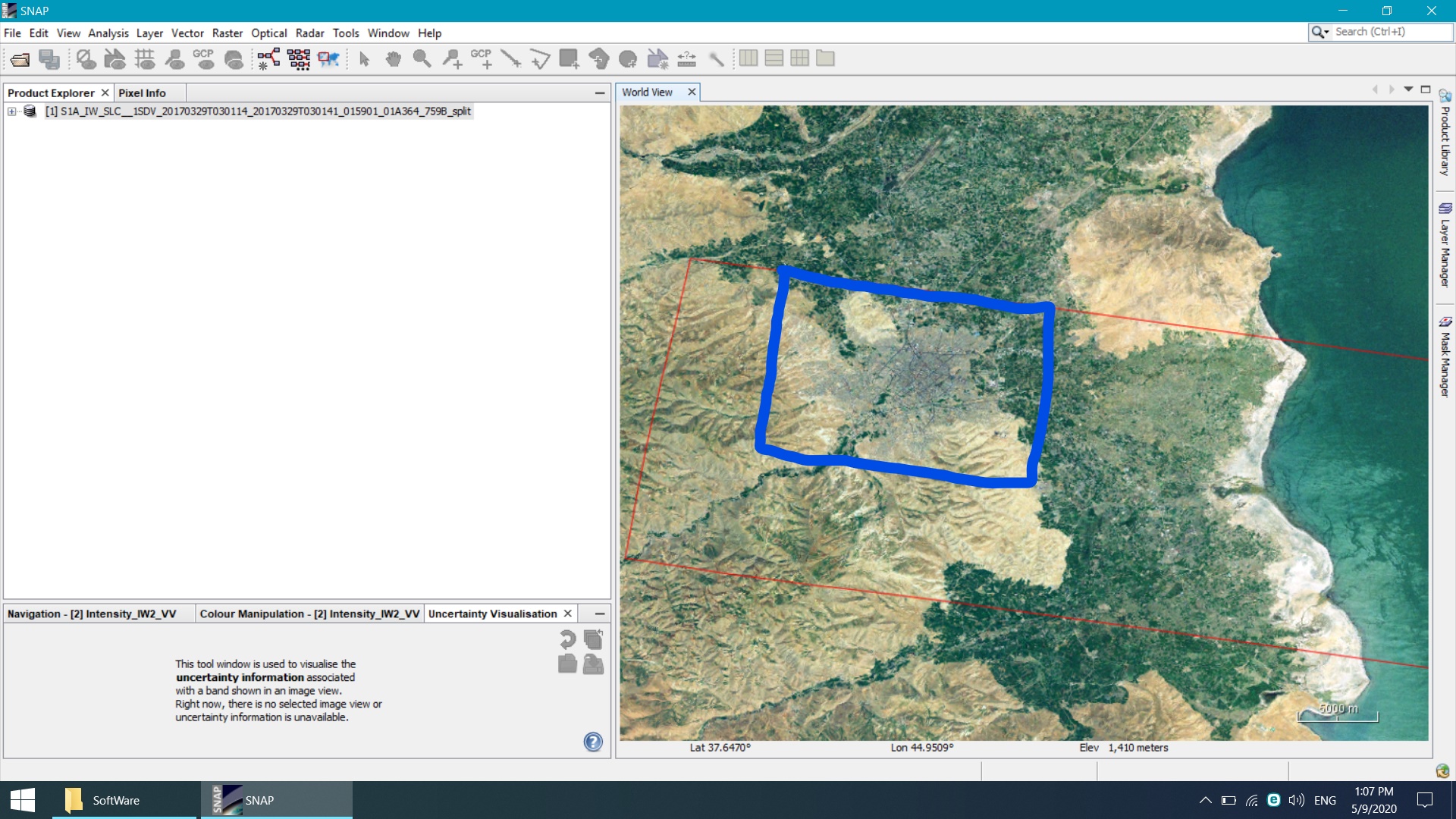
My researching area is this, I just wanna have that area for my work, how can I split that area?
if you are using SLC products you can create a subset after debursting the image.
if you are using GRD products you can directly create a subset in the beginning.
So it depends on your application in the first place.
i use SLC product,what’re the steps?
please tell me what you plan to do witht the data. The steps depend on your aims.
As a matter of fact I wanna export the growth rate of population by buildings
If your approach does not include radar interferometry or polarimetry, I suggest to use GRD products then. SLC data contains phase information at slant resolution, but after pre-processing, you end up with a ground resolution of at least 10 by 10 meters which is identical to what you can download as GRD product. This would save you a lot of downloading and processing time.
In this post, standard pre-processing procedures are suggested: Radiometric & Geometric Correction Workflow
As you mentioned radar interferometry is my requirement,
If my researching area be splited it would-be fine
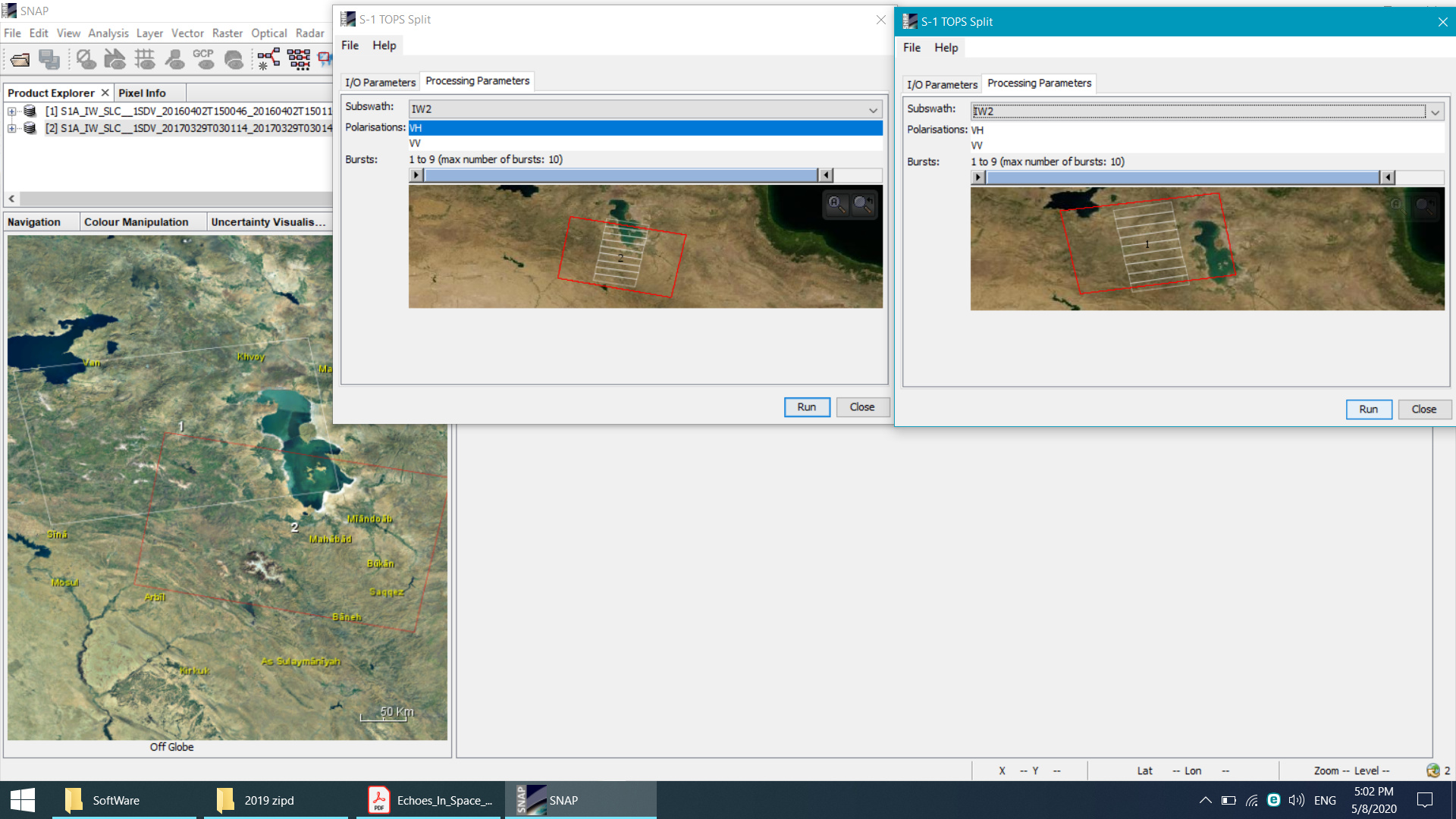
Split has to be performed on every SLC product because of the file structure. First you select the smallest number of bursts required to cover your area (see here). Once you have debursted the data, you can make a smaller subset.
By the bursts I’ve splited my Area as small as I could,
But by debursting I have no idea
You simply execute it after splitting to merge the bursts. After that you can create a subset.
Maybe the InSAR tutorials help you, although they are not aiming at urban areas in special
I’ve done this process(Sentinel-1 TOPS interferometry) not problem about it,
My problem is cuting my researching area
And the processes that should I go for my images
Echoes_In_Space_Urban_Footprint_Tutorial.pdf (2.3 MB)
The two images in file are for example but I should finish the all steps for my image in pairwise
You should have mentioned earlier that you are referring to avoid confusion.
In this tutorial the TOPS Split operator is referred to as “Data subset”, but it is actually just a required step to work with the data structure of Sentinel-1 IW SLC products.
So at which point do you have problems?
Step 13 can only be computed from two images of the same track.
Yes I know about step13
In pdf file you see that the city area is full screen it doesn’t have any another feature like mountains and lakes,…
For my project like that I just wanted to have my researching area lack of another feature ,but the method that you said me(spatial subset from view)
I split me researching area,
Is it right?
Doc1.docx (888.1 KB)