Hi Everyone,
I relative new in remote sensing. I want to ask a theoretical question about Sentinel-2.
Does resampling spatial resolution possible to do for all of the Sentinel-2 products, especially Level-1C? For instance, I want to uniform B1 - B12 spatial resolution to 20m . I just want to confirm it in terms of theory.
So I think you mean resamling of the spatial resolution.
The spectral resolution is measured in nanometers and defines the number and bandwidth of bands. There area also spectral resampling techniques, but these do not really fit to your question.
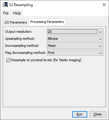
To resample all Sentinel-2 bands to a common resolution of 20 meters, you need the S2 Resampling Operator.
I just worried about exporting process using google earth engine. I exported my Sentinel-2 (Level 1C) image in 20m spatial resolution for all of its bands.
things are a bit different for the Google Earth Engine where S2 data are prepared for cloud access and each resolution is stored as a separate asset (described here)
Also the selection of a pixel size during the GEE export follows its own rules regarding scale and resampling.
As this is the SNAP forum, I assumed your question referred to the resampling of original S2 products in SNAP.
Yes, this is a valid operation in remote sensing. There are many applications where your data has to be stored at a defined spatial resolution, for example 20 m. The process which translates 10 and 60 m bands into 20 m is called resampling and it is one of the basic operations for image preparation.
You have to be aware that the information content of the images can change during this process and usually there are some parameters to define how the new pixel value is calculated under the new geometry (nearest neigbor, bilinear, bi-cubic…), but in GEE this is not very transparent and mostly done without asking the user. Still, you can use the output.
I have a question that fits well in this topic.
I have been searching explanations about the methodology used for the spatial downsampling of the bands. Unfortunately, I couldn’t find specifications.
Let’s say that I have an L1C image that I want to resample to 20m resolution. For me is quite intuitive (but I’m still not sure) that bands with 10m (B2, B3, B4) will be upscaled by averaging the value of 2 pixels in order to obtain 20m. But how are the 60m downsampled? the pixel is just splitted in 3 pixels of 20m? these 3 pixels will have the same value?
Hello guys. Seems I am faced with a similar challenge here. I want to extract some point values from my Sentinel-2 data. However, the points are sample plots of 20 m * 40 m in dimension. I want to downscale my sentinel-2 resolution from 10 m * 10 m to 20 m * 40 m. I will appreciate any suggestion on what to do, whether there are procedures I should take note of. Thank you in advance for your responses.
Thank you @ABraun for your response. I did exactly what you just mentioned, but I am advised to resample my sentinel-2 to see whether it improves my model because I am regressing forest biomass with Sentinel-2 bands and variables in my model. I am working with 65 field transect plots (points) with 20 m * 40 m dimension each while my Sentinel-2 resolution is 10 * 10. Does it not matter to resample the sentinel. What do you suggest I do? I would be glad to receive your suggestion.
I see, thank you for the explanation.
If you use nearest neighbor resampling, the result will not change at all, because the pixel values stay the same. If you use bilinear resampling (or another) the pixel values are altered. But I see little in doing so, to be honest, only if you extract the values by points.
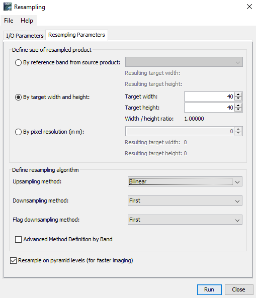
However, the S2 Resampling operator (under Optical > Geometric) only allows 10, 20 or 60 and the Resampling Operator (under Raster > Geometric) only allows square pixels. You can, technically, set 40 m and Bilinear so each pixel contains information of an area within 40x40m