Hello everyone, I want to using sen2cor process sentinel-2 for BRDF.
the document “S2-PDGS-MPC-L2A-IODD-2.5” as followed:
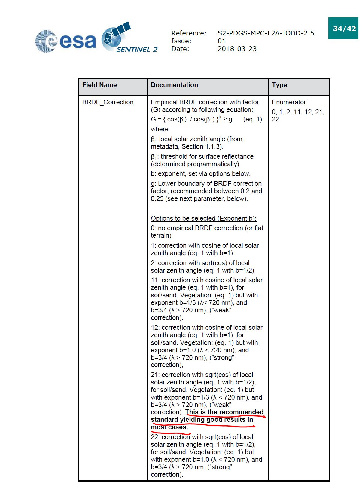
When I process test data by attach processing xml, setting the brdf parameter 0 and 21. But I finally find the result are same.
" L2A_GIPP.xml "
<?xml version=“1.0” encoding=“UTF-8”?>
<Level-2A_Ground_Image_Processing_Parameter xmlns:xsi=“http://www.w3.org/2001/XMLSchema-instance” xsi:noNamespaceSchemaLocation=“L2A_GIPP.xsd”>
<Common_Section>
<Log_Level>INFO</Log_Level>
<!-- can be: NOTSET, DEBUG, INFO, WARNING, ERROR, CRITICAL -->
<Operation_Mode>PDGS</Operation_Mode>
<!-- can be: TOOLBOX or PDGS. PDGS reflects changes for integration into PDGS according to SIIMPC-1119 -->
<Nr_Processes>1</Nr_Processes>
<!-- can be an unsigned integer value specifying the number or processes you intend to operate in parallel or: AUTO. If AUTO is chosen, the processor determines the number of processes automatically, using cpu_count() -->
<Target_Directory>DEFAULT</Target_Directory>
<!-- should be either a directory or ‘DEFAULT’. If default, target will be created at root of L1C product -->
<DEM_Directory>/home/tq/data_pool/SRTML1/srtm/tiles/GeoTIFF</DEM_Directory>
<!-- should be either a directory in the sen2cor home folder or ‘NONE’. If NONE, no DEM will be used -->
<DEM_Reference>http://data_public:GDdci@data.cgiar-csi.org/srtm/tiles/GeoTIFF/</DEM_Reference>
<!-- will be ignored if DEM is NONE. A SRTM DEM will be downloaded from this reference, if no local DEM is available -->
<Generate_DEM_Output>FALSE</Generate_DEM_Output>
<!-- FALSE: no DEM output, TRUE: store DEM in the AUX data directory -->
<Generate_TCI_Output>FALSE</Generate_TCI_Output>
<!-- FALSE: no TCI output, TRUE: store TCI in the IMAGE data directory -->
<Generate_DDV_Output>TRUE</Generate_DDV_Output>
<!-- FALSE: no DDV output, TRUE: store DDV in the QI_DATA directory -->
<PSD_Scheme PSD_Version=“13.1” PSD_Reference=“S2-PDGS-TAS-DI-PSD-V13.1_Schema”>
<UP_Scheme_1C>S2_User_Product_Level-1C_Metadata</UP_Scheme_1C>
<UP_Scheme_2A>S2_User_Product_Level-2A_Metadata</UP_Scheme_2A>
<Tile_Scheme_1C>S2_PDI_Level-1C_Tile_Metadata</Tile_Scheme_1C>
<Tile_Scheme_2A>S2_PDI_Level-2A_Tile_Metadata</Tile_Scheme_2A>
<DS_Scheme_1C>S2_PDI_Level-1C_Datastrip_Metadata</DS_Scheme_1C>
<DS_Scheme_2A>S2_PDI_Level-2A_Datastrip_Metadata</DS_Scheme_2A>
</PSD_Scheme>
<PSD_Scheme PSD_Version=“14.2” PSD_Reference=“S2-PDGS-TAS-DI-PSD-V14.2_Schema”>
<UP_Scheme_1C>S2_User_Product_Level-1C_Metadata</UP_Scheme_1C>
<UP_Scheme_2A>S2_User_Product_Level-2A_Metadata</UP_Scheme_2A>
<Tile_Scheme_1C>S2_PDI_Level-1C_Tile_Metadata</Tile_Scheme_1C>
<Tile_Scheme_2A>S2_PDI_Level-2A_Tile_Metadata</Tile_Scheme_2A>
<DS_Scheme_1C>S2_PDI_Level-1C_Datastrip_Metadata</DS_Scheme_1C>
<DS_Scheme_2A>S2_PDI_Level-2A_Datastrip_Metadata</DS_Scheme_2A>
</PSD_Scheme>
<PSD_Scheme PSD_Version=“14.3” PSD_Reference=“S2-PDGS-TAS-DI-PSD-V14.3_Schema”>
<UP_Scheme_1C>S2_User_Product_Level-1C_Metadata</UP_Scheme_1C>
<UP_Scheme_2A>S2_User_Product_Level-2A_Metadata</UP_Scheme_2A>
<Tile_Scheme_1C>S2_PDI_Level-1C_Tile_Metadata</Tile_Scheme_1C>
<Tile_Scheme_2A>S2_PDI_Level-2A_Tile_Metadata</Tile_Scheme_2A>
<DS_Scheme_1C>S2_PDI_Level-1C_Datastrip_Metadata</DS_Scheme_1C>
<DS_Scheme_2A>S2_PDI_Level-2A_Datastrip_Metadata</DS_Scheme_2A>
</PSD_Scheme>
<PSD_Scheme PSD_Version=“14.5” PSD_Reference=“S2-PDGS-TAS-DI-PSD-V14.5_Schema”>
<UP_Scheme_1C>S2_User_Product_Level-1C_Metadata</UP_Scheme_1C>
<UP_Scheme_2A>S2_User_Product_Level-2A_Metadata</UP_Scheme_2A>
<Tile_Scheme_1C>S2_PDI_Level-1C_Tile_Metadata</Tile_Scheme_1C>
<Tile_Scheme_2A>S2_PDI_Level-2A_Tile_Metadata</Tile_Scheme_2A>
<DS_Scheme_1C>S2_PDI_Level-1C_Datastrip_Metadata</DS_Scheme_1C>
<DS_Scheme_2A>S2_PDI_Level-2A_Datastrip_Metadata</DS_Scheme_2A>
</PSD_Scheme>
<GIPP_Scheme>L2A_GIPP</GIPP_Scheme>
<SC_Scheme>L2A_CAL_SC_GIPP</SC_Scheme>
<AC_Scheme>L2A_CAL_AC_GIPP</AC_Scheme>
<PB_Scheme>L2A_PB_GIPP</PB_Scheme>
</Common_Section>
<Scene_Classification>
<Filters>
<Median_Filter>0</Median_Filter>
</Filters>
</Scene_Classification>
<Atmospheric_Correction>
<Look_Up_Tables>
<Aerosol_Type>RURAL</Aerosol_Type>
<!-- RURAL, MARITIME, AUTO -->
<Mid_Latitude>SUMMER</Mid_Latitude>
<!-- SUMMER, WINTER, AUTO -->
<Ozone_Content>0</Ozone_Content>
<!-- The atmospheric temperature profile and ozone content in Dobson Unit (DU)
0: to get the best approximation from metadata
(this is the smallest difference between metadata and column DU),
else select one of:
==========================================
For midlatitude summer (MS) atmosphere:
250, 290, 331 (standard MS), 370, 410, 450
==========================================
For midlatitude winter (MW) atmosphere:
250, 290, 330, 377 (standard MW), 420, 460
==========================================
–>
</Look_Up_Tables>
<Flags>
<WV_Correction>3</WV_Correction>
<!-- 0: No WV correction, 1: only 940 nm bands, 2: only 1130 nm bands , 3: both regions used during wv retrieval, 4: Thermal region -->
<VIS_Update_Mode>1</VIS_Update_Mode>
<!-- 0: constant, 1: variable visibility -->
<WV_Watermask>1</WV_Watermask>
<!-- 0: not replaced, 1: land-average, 2: line-average -->
<Cirrus_Correction>TRUE</Cirrus_Correction>
<!-- FALSE: no cirrus correction applied, TRUE: cirrus correction applied -->
<BRDF_Correction>0</BRDF_Correction>
<!-- 0: no BRDF correction, 1: , 2: ,11, 12, 22, 21: see IODD for explanation -->
<BRDF_Lower_Bound>0.22</BRDF_Lower_Bound>
<!-- In most cases, g=0.2 to 0.25 is adequate, in extreme cases of overcorrection g=0.1 should be applied -->
</Flags>
<Calibration>
<DEM_Unit>0</DEM_Unit>
<!-- (0=[m], 1=[dm], 2=[cm]) -->
<Adj_Km>1.000</Adj_Km>
<!-- Adjancency Range [km] -->
<Visibility>40.0</Visibility>
<!-- visibility (5 <= visib <= 120 km) -->
<Altitude>0.100</Altitude>
<!-- [km] -->
<Smooth_WV_Map>100.0</Smooth_WV_Map>
<!-- length of square box, [meters] -->
<WV_Threshold_Cirrus>0.25</WV_Threshold_Cirrus>
<!-- water vapor threshold to switch off cirrus algorithm [cm]Range: 0.1-1.0 -->
</Calibration>
</Atmospheric_Correction>
</Level-2A_Ground_Image_Processing_Parameter>