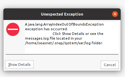
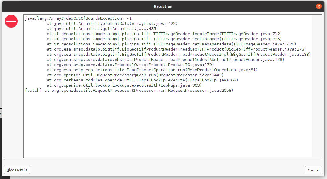
I have installed recently SNAP 8. Since that, I have problems to load GeoTIFF-BigTIFF images, generated using SNAP/gpt operators. There were not problems with previous SNAP version. Please find enclosed screen snapshots and SNAP log file.
I have performed some aditional tests, the problem is related to GeoTIFF-BigTIFF format. The standard GeoTIFF images are opened without issues by SNAP, however the GeoTIFF-BigTIFF images are not.
I have produced using the same data, GeoTIFF and GeoTIFF-BigTIFF images. There are no problems with the first ones, conversely the second ones are not opened by SNAP.
Please find enclosed the output error messages (gpt_error.txt), from attempts of gpt processing that try to read GeoTIFF-BigTIFF images.
Note that is a reading issue. The tests also have been performed using GeoTIFF-BigTIFF images writed using gpt Write operator (SNAP 8.0 version). These GeoTIFF-BigTIFF images were opened correctly using other tools and the previous SNAP version.
It is a little bit surprising to me that no other people have reported the same issue.
The problem remains. I am experiencing the same problem with SNAP 8.0 running on linux ubuntu and mac OS operating systems. As I told in the previous posts in this topic it is a reading problem. The images GeoTIFF-BigTIFF images are created using SNAP Write operator, however SNAP is unable to read them. However other applications or libraries can read these images without problems
I have uploaded an example of GeoTIFF-BigTIFF image generated using SNAP (S2A_20210113_T27RYM_sen2cor.tif), please find enclosed the xml file that generates it (S2_sen2cor_resampled_bandmerge_S2A.xml). This particular case corresponds to S2A data processed using sen2cor. The input files were: bands 10 m, bands 20 m, bands 60 m and some viewing (and quality) bands. All products were previously resampled to 10 meters. In this case the input files to the xml one were BEAM-DIMAP produced using SNAP/gpt.
I am experiencing the same problem with other data. I did some time ago, some tests with smaller files, that did not require GeoTIFF-BigTIFF format. SNAP was able to open them when were generated as GeoTIFF, however was not when were generated as GeoTIFF-BigTIFF
Just to remember that other tools manage these GeoTIFF-BigTIFF
correctly. Please see the jpg uploaded (S2A_20210113_T27RYM_sen2cor_RGBV2.jpg)
, generated from S2A_20210113_T27RYM_sen2cor.tif
using gdal and PIL python modules.
I have updated SNAP to 8.0.3 where de GeoTIFF-BigTIFF problem was expected to be solved. However I am still experiencing problems.
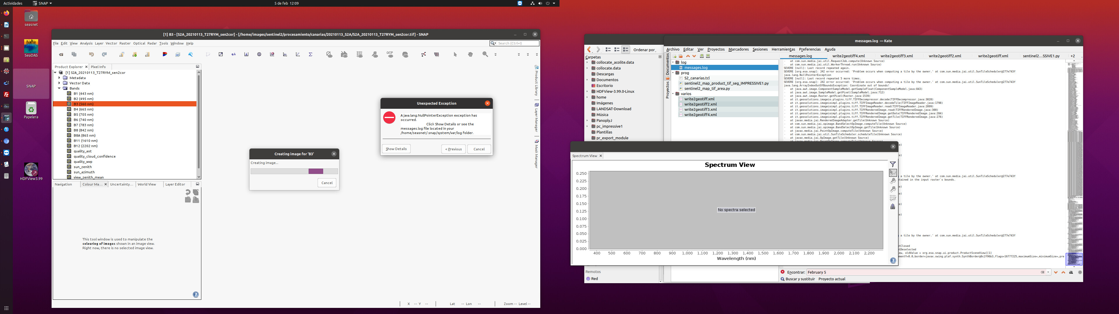
Unlike the previous version (8.0.2), now the images are loaded in the SNAP product explorer without problems. I can see the image information throughout the product explorer (metadata, band names,….)
I can load a band few times (not always correctly) and explore the image, use the spectrum view,… However I never can not load a RGB image properly. The visualization fails, but the behavior is not always the same sometimes the RGB is not produced and error messages are delivered and sometimes a visualization is produced although it is not correct (see messages.log)
I have tried to read and subset bands using gpt, and the process failed. Please find enclosed the xml used (write2geotiff2.xml) and the outputs from gpt (gpt_output.txt).
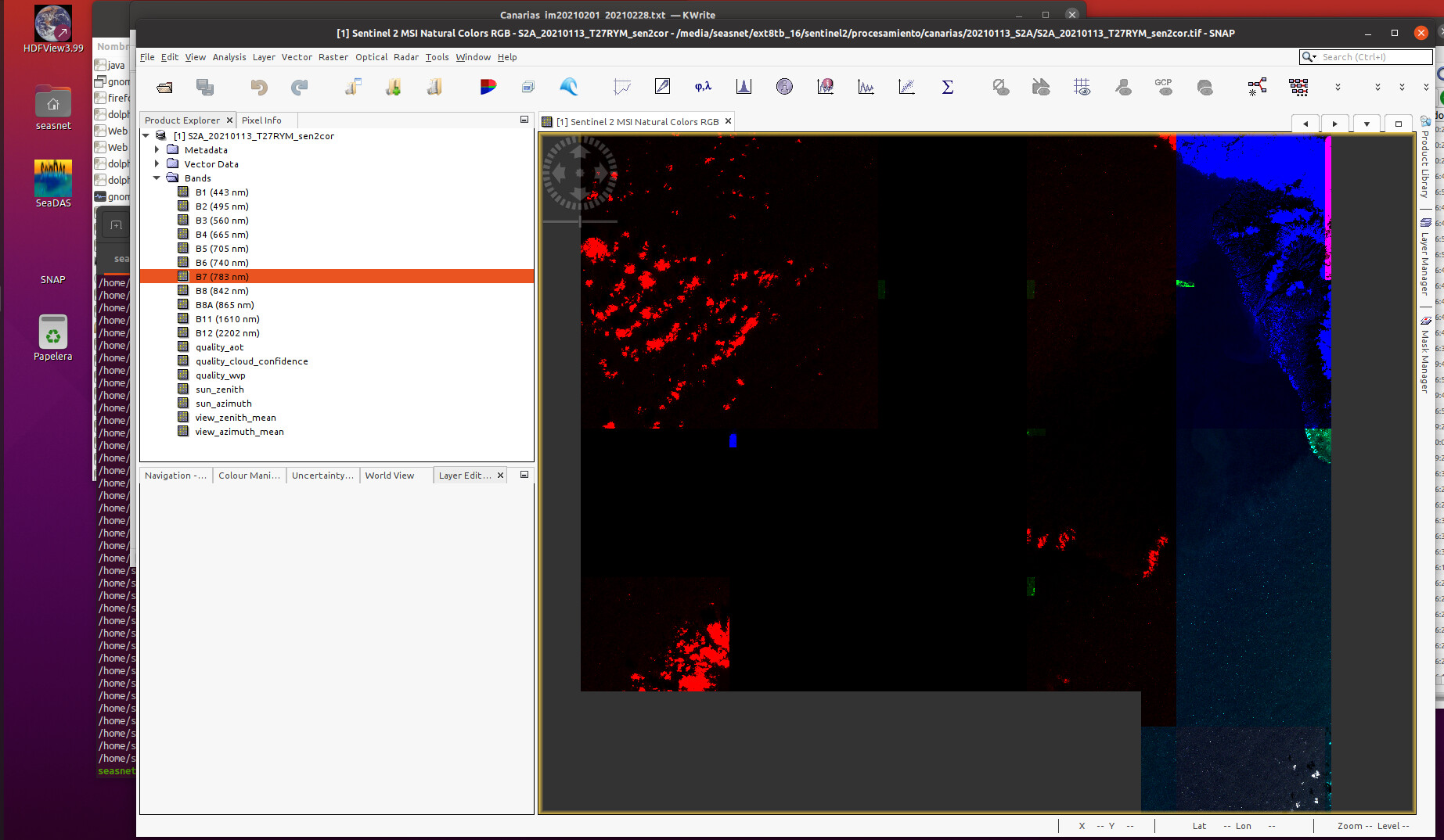
The binary pconvert is able to generate a jpg using the GeoTIFF-BigTIFF images, althouth some error messages were delivered (pconvert_output.txt). I have used for the test several images, including the image that was uploaded as example (S2A_20210113_T27RYM_sen2cor.tif)