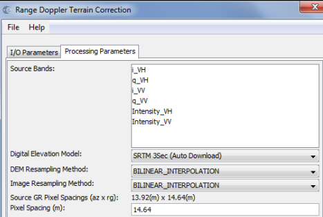
I have noticed that pixel spacing (m) has by default the value of the largest dimension of source ground pixel spacings (azimuth x range), why?
I realized that, after terrain correction, source ground pixel spacings (azimuth x range) represents the sizes of the pixels in the image, but I don’t understand well what is pixel spacing (m) in the image.
Could you write the correct definitions of source ground pixel spacings (azimuth x range) and pixel spacing, please?
In remote sensing, spatial resolution is typically limited by diffraction, as well as by aberrations, imperfect focus, and atmospheric distortion. The ground sample distance (GSD) of an image, the pixel spacing on the Earth’s surface, is typically considerably smaller than the resolvable spot size.
Then, azimuth resampling to the desired output pixel spacing. This compensates for the range-depend pixel spacing at the output of deramp and FFT. This may also include averaging to extract additional azimuth looks.