TOPSAR Split and Merge with different swaths/bursts

Hi @ABraun

I also have a region that I need to create a DEM which overlaps swaths IW1 & IW2.
Furthermore, I also wish to process only the subswaths of each swath that contains my ROI
I have read the posts above, however I am still confused on the process.

Could you please check my workflow:

For IW1 and IW2:
(1) Coregistration (TOPSAR split + apply orbit file)
(2) Interferogram formation
(3) Deburst

Once steps (1) to (3) have been completed for IW1 and IW2 then:
(4) TOPS merge?

Sorry, I’m not experienced with analysis of two swaps and am not sure ar which step the merge should occur ar best.
I would test it directly after the TOPS coregistration step. What happens when you apply Merge after debursting as you suggested.

Just a remark on DEM generation. The results are often very bad compared to freely available DEMs like SRTM or AW3D30, despite of the higher spatial resolution, because of temporal decorrelation over vegetation and atmospheric artefacts.

Use image pairs with a temporal baseline as short aa possible and a perpendicular baseline larger than 100 meters. Also, avoid data from rainy days.

1 Like

@ABraun thanks again for the speedy reply and clarification

I’ve kept Btemp to <= 24 days, and 300m>Bperp>=100m However, this is the best I get:

This is what a profile of my DEM vs SRTM looks like: (elevation and distance in metres)

Here is my DEM. I do not understand why it looks like this

This is the coherence:

When you say that the results are often bad, is this what is generally obtained, or should I see if I can get better results?

Thank you

not bad! You already did anything to create a good DEM (baselines, data…), there is no bad trend in your data and the overall elevations seem very reasonable. I just gave these hints because many people expect any SAR data pair to produce flawless DEMs without knowing about the error sources.

I see a few unwrapping errors in the middle left. Maybe you can try unwrapping again with SMOOTH instead of TOPO but I can’t promise that this will solve them. But you can simply copy the exported folder, change the snaphu.conf file directly (open it with a text editor) and run it again.

For a Sentinel-1 DEM this is fine I would say, most others I have seen are way worse. Another successful example: The Order of DEM Creating Steps

1 Like

Thank you @ABraun! All your help is much appreciated :smiley: I will try unwrap export with Smooth.

One last question, please. How does one visually identify unwrapping errors?
Also could please let me know if you are referring to the region within the red circle (below). It is a reservoir:

the errors you highlighted are probably because of low coherence in the valleys (wetlands?).
Unwrapping errors are unnatural phase jumps such as here:
grafik

1 Like

@ABraun Ok, I understand. Thanks again.

And yes! It is a valley of sorts - its a mostly empty dam. This was when the dam was at 14-18% capacity.

Hi Dear falahfakhri
How can I process the area inside the two subswath (half inside IW1 and half inside IW2)
Thank you, if you tell me your orders.

So have you figured out at which step should we begin merging two subswaths? I have got the same situation too, my study area lies between two sub-swaths of 2 and 3 bursts of Sentinel 1 SLC images. I am afraid scalloping effect would be an issue

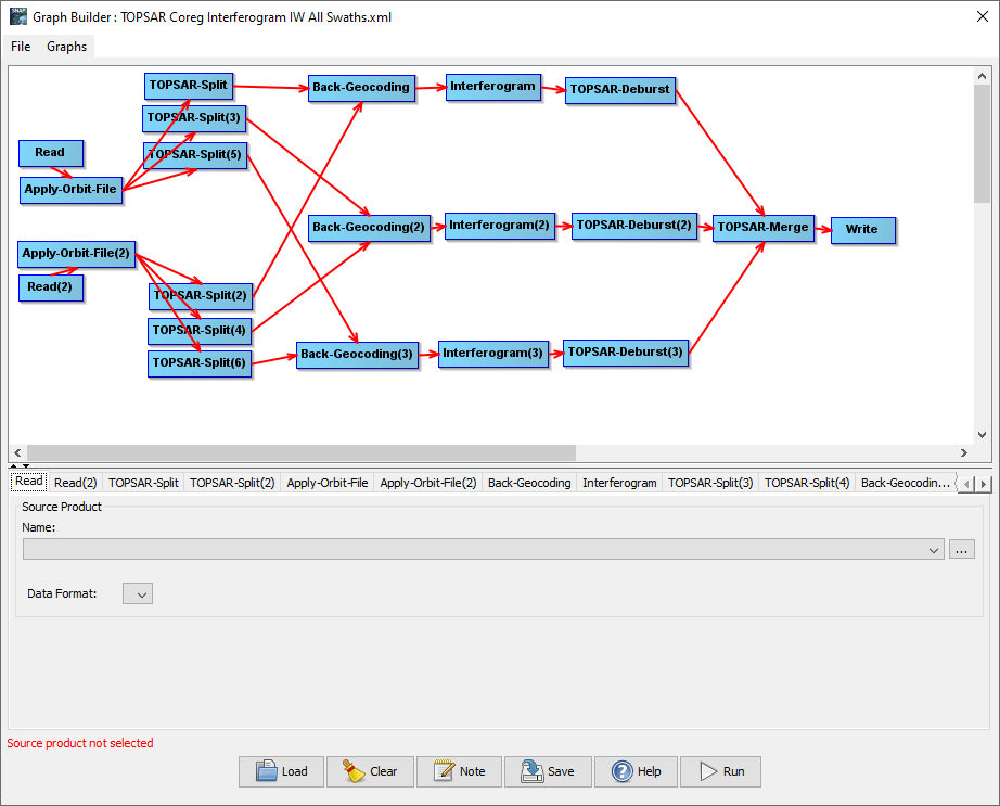
according to the predefined graph in the Graph Builder, TOPS Merge comes at the end of all processing steps.

2 Likes

I will try this but I am still skeptical the unwrapping would be a bit too erroneous when performed on a merged sub-swaths after perhaps at least 12 hours processing? I will mention a feedback after completion

If you need such large areas you should consider multi looking to reduce the data volume.
Also unwrapping only works with consistently high coherence, so please don’t expect too much at this spatial scale.

1 Like

please , I want to create total interferogram for the three subswaths(IW1,IW2,IW3)to study earthquake I merge deburst interferogram from IW1 and IW2 and IW3 and then I apply (Goldstein Phase Filtering and Geocoding) and every thing is okay


But when export view as Google Earth KMZ the image is not total

looks good to me, although phase quality seems to be degraded in the low lands, probably because of temporal decorrelation. But at least there are no phase jumps along the burst boundaries which is good.

1 Like

Thank you ABraun …another question please …how can I calculate vertical and horizontal components of the displacement caused by earthquake in SNAP using relations:
image

I have a question please. Will phase jump occur if I create a number of interferograms from multiple bursts groups (Say three bursts at a time) and then combine them, instead of creating a single interferogram from an entire subswath at once?
Because comparably, the latter takes way too much time as if the time required for processing increases exponentially with increasing the number of included bursts. And sometimes it ends with crashing the machine.

@marpet what is your opinion about this if you wouldn’t mind?
I have trying creating an large interferogram of 9 bursts and other smaller interferograms each has three bursts, then compared the complete one to the smaller ones side by side and norticed no difference and no discontinuty of the fringes between the smaller interferograms. But I still can tell for sure because I cannot perform Slice Assembly due to some error in this particular operator

Hi SNAP Experts,
My own case is more like the reverse. I want to process all the three swaths simultaneously, but the topsar split operators (2) and (3) could not recognize the input data. Please how can I solve this problem? Thanks for your supports ahead.

Hello Everybody,
Greetings !!!
I am trying to process InSAR image and i find that my research area lies in two different sub-swath but the burst is same (Burst 1 to 4). i tried to follow the discussion above but different people have tried different technique for merging different sub-swaths which is little confusing. I am initial beginner of this SNAP software and InSAR processing. I would like to request all the above expert which is the correct way of merging two different sub-swath. Please let me know if there are any tutorials or videos on solving this problem. I am not sure whether i should have asked this silly question in this forum or not.
Diwakar

@ABraun Hello Sir, How did you correct your error of phase jumps, because i am also facing same error of phase jump in my research area too. Yours suggestion will be highly appreciable.

Diwakar