However, I suggest you use a different approach - calculate the measured radar cross-section of your point targets (I assume these corner reflectors) and compare with the theoretical radar cross-section of your CRs. Ideally the differences should be small.
how to find in which subswath of SLC IW image, does our location falls since subswaths when displayed using snap tool shows same lat long for each subswath
I need guidnace to merge 3 subswaths into single SLC image
thank you
Mr. Peter
I tried hard to locate corner reflector in SLC , IW image of Sentinel 1A
Mr. peter, could you assist me to locate corner reflector ( trihedral triangular , 1m) in SLC image
deployment location: lat 12°38’15"N long 77°26’25.72"E
Dates of deployment: 21/07/2017, 2/8/2017, 7/9/2017, 25/10/2017, 18/11/2017, 6/3/2018
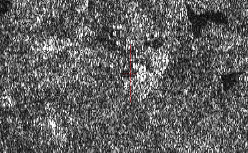
Hi, I have obtained one of your image - from 06/03/2018 - and located your corner reflector. It is at pixel coordinates 10177, 12657 in sub-swath IW2. The cross in the image below shows the predicted position using a terrain height of 660 m. The CR will be at a similar position for your other images.
Hi, could you please expand on which angle you are wanting to calculate and why. For example, is it the incident angle at your location from the product annotation. Many thanks.
Hi peter,
We have plans to deploy dish antenna to monitor S-1A signal strength for which antenna has to be aligned along LOS of the satellite view based on elevation angle. Hence elevation angle is needed for my location: lat 12°38’15"N long 77°26’25.72"E
kindly guide me
thank you
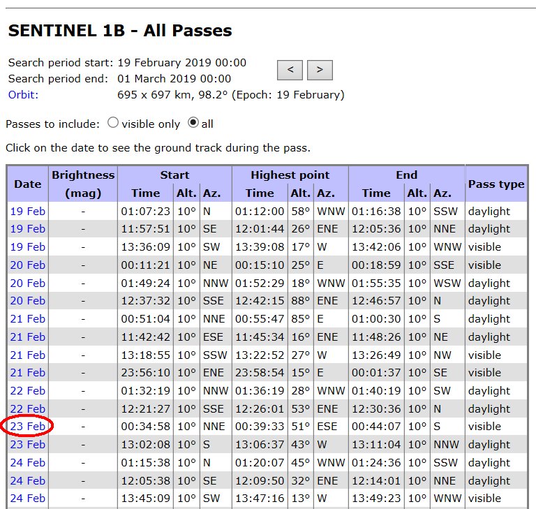
Hi, I suggest you use the Heavens-Above (HA) web site (https://www.heavens-above.com/) to find the altitude (=elevation) and azimuth for the pass you are interested in. To use HA you will need (I) to set your location (e.g. Devarakaggalahalli) and time e.g. GMT+0hrs, (ii) select a satellite, e.g. S1-A from the ‘Satellite Database’ link down the left hand side of the HA home page. Once you have found Sentinel1-A, select ‘All Passes’ to give a list of when S1-A will be above the horizon from your location. If you click on the date for each pass, you will get more information, including at the bottom, the altitude and azimuth at Maximum Altitude.
I would like to know if there is any restriction on publishing the contents of S- 1A images in the international journals
2nd query is
can I know Sentinel pass dates for the coming days of March and April month
hi
displaying Sentinel 1A images using SNAP takes long time ( more than 30 minutes)
how to speed up the process
what are the minimum work station requirements to process S1 and s2 images using SNAP
I strongly recommend at least to use SSD for usage (then, you can use HDD for storage). Also I recommend at least 16Go RAM. In terms of CPU, the stronger the better but CPU is not really a bottleneck of SNAP operation whereas lack of RAM clearly prevents SNAP from using some functionalities.
Hi
thank you for earlier responses
what is velocity of the Sentinel 1A satellite/sensor
Is it possible to obtain information on the slant range of every pixel of S-1A , IW, GRD image using SNAP tool
kindly guide
thank you
You can use the S1 TOPS Coregistration which contains all necessary steps but it allows to only select one swath in the Split tab. So you have to do this for all three swaths and then apply S1 TOPS Merge.
This entire graph takes quite much resouces, so you can also perform the single steps individually.
Split
Apply Orbit file
S1 BackGeocoding
In any way, you need to apply S1 Deburst to later joint the single bursts of your swath after the coregistration.
The sentinel 1A data for the year 2018 of the loctaion: latitude 12 deg and longitude 77 degree
has become offline . what is the way we can get access to data of the year 2017 and 2018 for all months
kindly guide