I am planning to use the WCM for bio-physical parameters retrieval in my research. But I am not clear about this model. Can the people using this model explain and share some tips??
1 Like
does water cloud model is a software package
Yes. It is a package in R.
Ohh thank you can you share me some materials related to this please
1 Like
is there anyone who can help me to find water cloud model software package
what about PolSARpro?
https://cran.r-project.org/web/packages/WCM/index.html
I found this package in R to be useful.
Does PolSARpro has WCM? Can we use it for agriculture related applications? I never knew that. Can you share some content related to this @ABraun ?
It’s not my main expertise to be honest, but I’m not sure what you expect from it. There is no WCM-button you press and magically get answers  You need a bit of understanding of the inversion process and how it is used to separate moisture from the other factors contributing to backscatter.
The tutorials inside PolSARpro can be a good start:
But you need quad-pol data for it.
1 Like
Thank you so much
Hi,
For Cloud Water Model using SAR, you can have a look at the this github repository.
There is an implementation of CWM for both optical and SAR in python.
Hi,
I’m Jefflin doing a project in Surface Soil Moisture(SSM) retrieval. I’m beginner in the SAR data processing. In this i’m using Sentinel 1 data. I had done all the preprocessing steps. After that i try to extract the SSM using Water Cloud Model(WCM). I have a doubt in Band Maths in SNAP. How to make an expression using indices from two files. Algorithm is exp(-2 * B*LAI * sec(incidence_angle)) In this LAI is used from the optical data while the incidence_angle is used from the RADAR data(Downloaded base file).I don’t know how to make the expression combining both the radar and optical datas.
Thanks in advance…
once you have pre-processed your SAR data (and geocoded it into the same coordinate reference system of the optical data), you can use the collocation tool to store both products into one product and use the band maths operator using bands of both datasets to formulate your expression.
1 Like
@ABraun Thank you soo much…i will try it…
Hi,
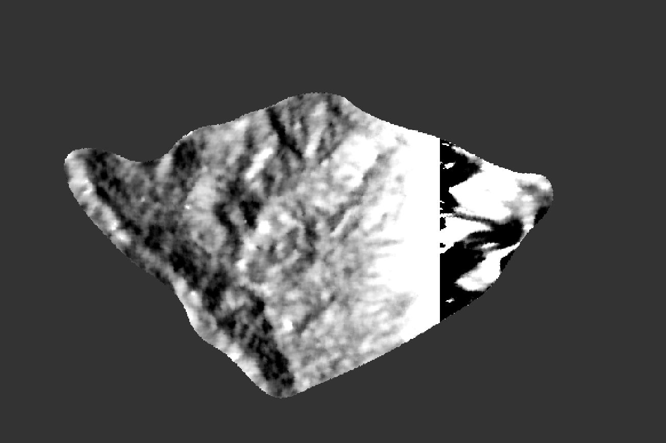
I’m working in soil moisture extraction using Sentinel-1 data. In this i had done all the preprocessing such as radiometric calibration, speckle filtering and terrain correction. I adopt Water Cloud Model(WCM) for this, and made then band math expressions but the output is like this shown below.
In the image you can see the right side is blackish and the soil moisture values are from negative . i think something went wrong. Can anyone help me to correct it.
Hi,
Are you sure you have applied the WCM properly?
For WCM ot be derived, there are three different equations as given by Baghdadi et.al (2017)
-
sigma_totwhich is the signal contribution from the whole canopy and soil -
sigma_vegwhich is the signal contribution from the vegetation only -
Twhich is the attenuation factor
In order to apply WCM, you would also need in-situ measurements of soil moisture and soil roughness.
Those values derived from field measurements can be used to the equations described on the paper below.
To derive soil moisture [m^3] from SAR, you would need a regression analysis between soil moisture derived from the field and the backscatter intensity data from Sentinel-1
The equation you have posted above ( exp(-2 * B*LAI * sec(incidence_angle))) I do not think is enough for the WCM, unless you implemented all the other necessary steps
Baghdadi, Mohammad and Bousbih (2017) Calibration of the Water Cloud Model at C-Band for Winter Crop Fields and Grasslands: Remote Sensing
2 Likes
yes sir, i applied WCM properly. I provide LAI as the vegetation descriptor, and the soil and vegetation parameters as determined from in-situ measurements.
sir, i do WCM by the full expression sigma naught total = sigma naught (veg) + T (square) *sigma naught (soil)
If you applied the WCM correctly, the resulted soil moisture image should be in m^3 (assuming the field measurements of soil moisture collected are in m^3).
What are the values of the image you posted?
Having negative values, indicates that something must have gone wrong when implementing the equations
1 Like
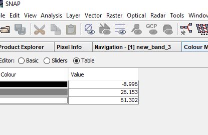
sir, here you can see the values. i had given the soil and vegetation parameters in cm^3.