I believe it must be this one… I am glad that the forum search works pretty nicely!
1 Like
Hello!
Thank you for your help!
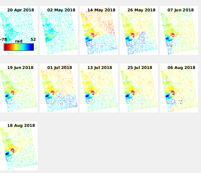
I got these results from stamps(6,6). Image attached.
Is this the final output or anything else is required? I do not know how to do atmospheric filtering,
I am glad you solved it with our help. 
It looks a bit noisy to me, if what I see is a sea (covering most of the centre and eastern part of the image)
Stil, clear subsidence and uplift happens there.
My first suggestion is to extend the images you analyse. This is why you got a lot of noisy points over what I believe is water.
Had you run step 7? this not only removes orbit ramps (if you select the option), but other kind of errors (if I remember properly).
Regarding the atmospheric phase screen estimation/removal (APS), you can use the step 8, which applies spatio-temporal filtering.
Hello!
You are right. This area is the island of Hawaii.
I did not understand this step -
I have run step 7. But I am not sure how to get the images in step 7.
I ran step 8, but it gave me some error. Anyway, since this was my first time, I processed only one sub swath. I am merging different sub swaths now. I will re do the entire process with merged subswaths. I will let you know if I run across any other problem.
My suggestion is due to the fact that for obtaining accurate results, as some of the processes uses mathematical estimators, need to have high number of samples to discriminate signal from noise, even from the starting point of amplitude dispersion.
Normally works/papers in literature used at least from 20 to 30 images (in my work over Rome I have used over 80 images per orbit). The more the better. Now, using Sentinel-1, you can get larger number of images to process. But obviously it depends as well of the period of time you want to analyse.
Pre-eruption ? Hence, you can get data even some years back. If you do not want to get such large time series you can discard some data, let say getting one sample every 12, 24 or 36 days. For example, past missions (ERS and Envisat) had 35 days revisit and we were working with them. So you can for example get 1 data each 24 days, enlarging the analysed period without enlarging that much the amount of data available for processing.
1 Like
Ok. I got it now. But my time of interest is just the 2018 eruption so I am using just 3 months of data. But your suggestion is nice. I will definitely look at that after my thesis!
1 Like
If you don’t want anybody asking you why you only used 12 images… instead of 20, I would slightly increase the data employed. After all 8 images are not that many more.
Good luck with your thesis. InSAR is a very nice world!
Thank you!
I guess your suggestion to use 20 images instead of 12 makes more sense. I will get it going right now!
1 Like
Dear,
Thank you very much for your collaboration in this forum, it has helped me a lot in the learning of interferometry.
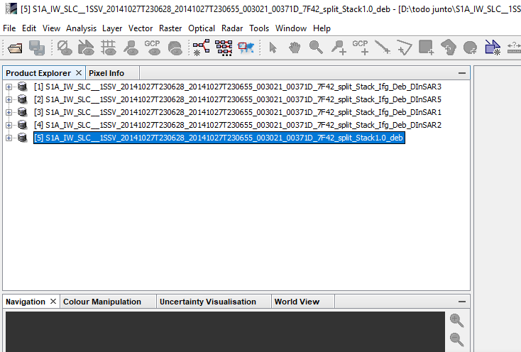
I wish I could work with Stamps but I can’t export the files.
Attached image with workflow and results.
At the moment I want to test the methodology so I will only use the minimum of images.
I would be very grateful for your help!
You can use the snap2stamps which surely will allow you to reach the StaMPS export step.
with your workflow… I hope you did that after splitting the images in the same subswath and you got not problems with the DEM during the topo phase removal. These are the common issues.
Another issues are the configuration of SNAP/GPT regarding memory allocation. You need to adapt it to your computer resources.
Hello!
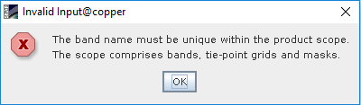
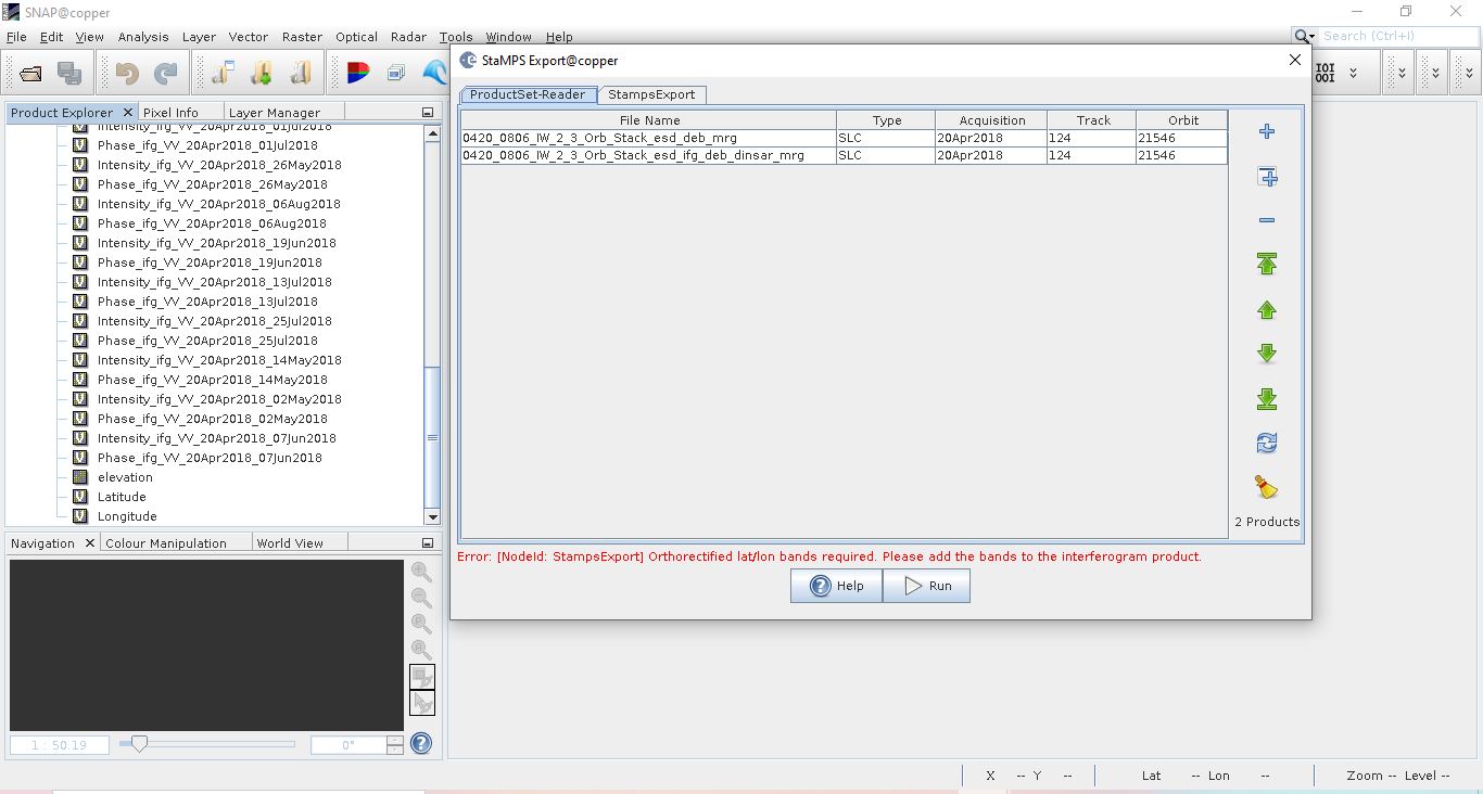
I tried to mege two subswaths and tried to use Stamps export, but somehow I am getting this error (Image attached).
Can you please tell me what is wrong?
Thank you!
P.S. I had added lat/long bands in topo phase removal step, but they seem to disappear in merge. Is there any other way to add bands?

you can add them after the merge agian.
For elevation: right-click on the stack and select “add elevation band”. Then click “File Save product” to make the changes permanent.
For tha lat/lon bands: Open the Band Maths and create two separate rasters latidude (expression y) and longitude (expression x) and again save the product.
Hello!
Thank you for help!
Can you please explain this step? When I tried to create latitude and longitude bands, I get this error (Image attached). Tie-point grids has both latitude and longitude bands.
Is naming important or any name will do?
Thank you!
Hello, I would like to get help with the ps_shapefile function, someone can give me an example of its execution. I’m not sure what each parameter represents, especially step.
function ps_shapefile(filename,data,step)
hmm, there are two tie-point grids with this name already. I am not sure how the stamps export handles this. Try to rename the tie-point grids and add the lat/lon bands afterwards.
Hello again!
This might be a stupid question, but can you please tell me how to rename bands?
I tried to use just Lat and Long names to create new bands, but Stamps export is giving same error. I will try to create the interferograms again with topo phase removal step combined.
Thank you!
currently, the problem is that the tie-point grids are named like the bands which are currently missed by the StaMPS export.
You can right-click on the tie-point grids and rename them to latitude_y and longitude_x, for example so that you can use the band maths afterwards and give the actual bands the names latidude and longitude.
However, this should not be a problem in the normal StaMPS preparation. Which workflow did you follow? Anything you made different maybe?
1 Like
Hi!
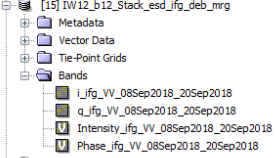
I was able to rename the tie-point grids and add new latitude longitude bands. Still, I am having the same error. Image attached.
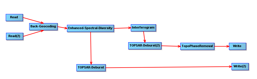
I don’t think I did anything different this time. Only thing I added was I merged two sub swaths. This is the workflow -
For both IW2 and IW3:
TOPSAR split
Orbit file
Single master stack
Enhanced spectral diversity
Interferogram formation with topo phase removal (Did not add elevation or lat long bands)
TOPSAR deburst
TOPSAR merge both IW2 and IW3
Add elevation band
Rename tie-point grids
Add lat long bands
Can you please tell me if this was right method or I did mess somewhere?
Thank you for help!
I have tested your issue for a simple case (only 2 products - makes no sense but is technically the same)
Reproduction of your error
- Split IW1
- Split IW2
- Backgeocoding IW1
- Backgeocoding IW2
- ESD IW1
- ESD IW2
- Inteferogram IW1 (including export of lat/lon/dem)
- Inteferogram IW2 (including export of lat/lon/dem)
- Deburst IW1
- Deburst IW2
- TOPS Merge
After the merge, both elevation and the coordinate layers are gone - like in your case.
Solution
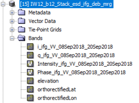
However, I noticed that the product name of the lat/lon bands is not latitude and longitude (as I initially thought), but orthorectifiedLat and orthorectifiedLon.
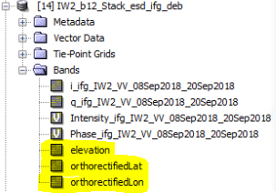
Maybe you can perform the merge again and then create bands with these names (in the context menu [add elevation band] and band maths [advanced expression editor > shor tie-point-grids]).
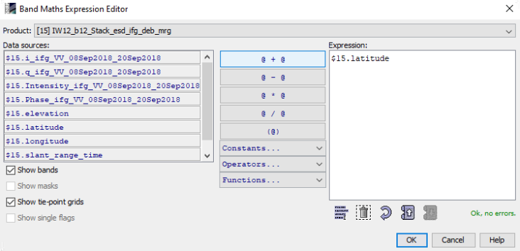
I tested it and added the bands after the merge:
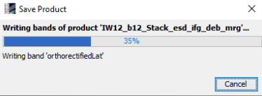
and finally saved the product (this takes some time)
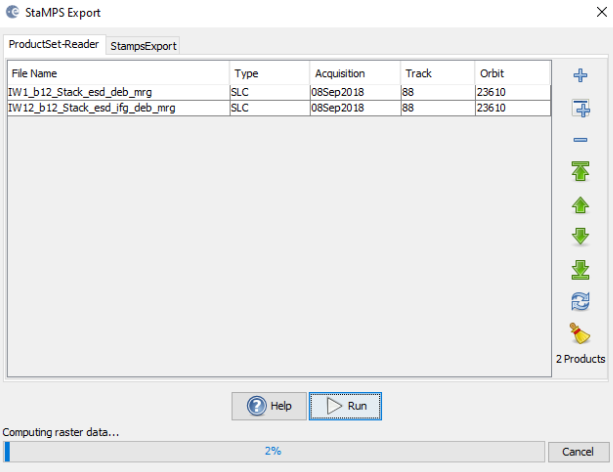
and there is no longer an error message:
Result
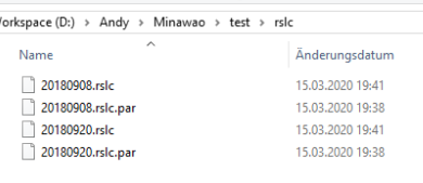
These are the exported folders
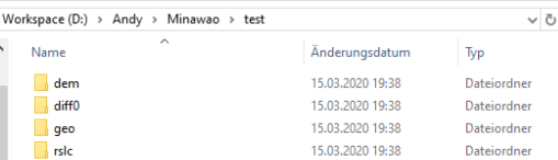
dem
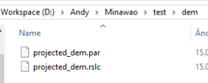
diff0
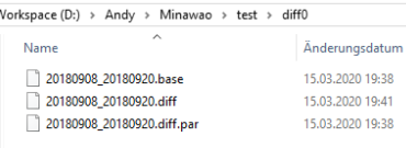
geo
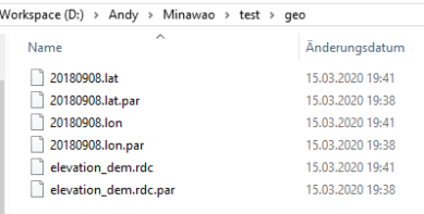
rslc
1 Like
Ok, so I think I know what the problem is. The problem lies in saving the orthorectified lat long bands. On my software, when I add the bands, they look fine. When I saved elevation band, it saved properly. But when I tried to save lat long bands, there is no (saving…) window appearing. Even then, when I closed the stack and opened it again, both lat long bands are there. Can you please tell me what can I do to save the bands properly?
I just noticed a tiny difference. You have used the O letter small, while I have used capital. I will try again with small O to see if that makes a difference,
