have anyone done avalanche detection in SNAP with sentinel 1 data.
I am finding difficulties in applying layover and foreshortening mask to my data.
I tried SAR simulation, but my results are not good.
There are two options “SAR simulation” and “SAR simulation Terrain Correction” which one should I choose. What are the exact steps for Layover and foreshortening mask.
Also is it ok to used 30m ASTER DEM with 10m SAR for Terrain Correction?
Please help, any reply would be much appreciated.
Thanks in advance.
In this topic we discussed the extraction and use of the shadow and layover mask: Remove sentinel 1 shadow
Maybe this helps?
1 Like
Hello ABraun, thankyou for replying. I read the mentioned post you shared with me. But as I am new to SAR and the topic you shared is different, I couldnt get it. Could you please help me to detect avalanche in my study area (region in himalaya)
I read many papers but couldnt follow , because i belive their topography is different and mine is different.
So for preprocessing i did thermal noise removal > calibration> speckle filtering in Graph builder.
After that i am not able to proceed, i dont know what do first, terrain correction or sar simulation terrain correction.
I’m not an expert in this topic. For the pre-processing - if you need the shadow and layover mask, you first apply the SAR Simulation to get it and then terrain correct it.
One way to test for avalanches would be to analyze multiple image pairs for loss of coherence. But this requires SLC data and procudes large amounts of data.
1 Like
Hi ABraun
Can you please tell me if how to get backscatter with single image before going to multi-image analysis.
I tried getting sigma0 which I though is backscatter only, but my results are not good.
I am using aster dem 30 m for terrain correction. And the complete workflow that I am following is
thermal noise removal >calibration>speckle filter> sar simulation > terrain correction
Am i missing anything?
actually, radiometric calibration results in Sigma0 (=radar cross section) as backscatter intensity.
I’m not sure what you mean with “single image before going multi-image analysis”.
Once you calibrated the products, they are radiometrically comparable.
1 Like
thankyou for your reply ABraun.
i mean by single image analysis can i notice the desired feature in an image of a particular date without any RGB composite image.
For multi image analysis we actually process two different images one for reference and one to be compared and then make a RGB image with those images. I dont want to do that.
I want to process a single image and find the avalanche. is that possible i am asking, any idea?
So you want to identify an avalanche in an area based on a single radar image?
Sounds quite challenging to me, because we don’t know how backscatter changed before and after the avalanche and also if backscatter changed at all. Also depends on the size of the landslide.
If I had to do that, I would do one of the following:
- compare two GRD backscatter images (one before and one after the landslide) and see if there is a significant difference (SNAP has a change detection module based on the log-likelihood approach)
- calculate the coherence between three dates (A+B both before the landslide, B+C before and after the landslide) and search for an area with strong decrease of coherence (example)
1 Like
thanks for your inputs ABraun
if the images are not close, like 10 days difference between the available data, will that affect my results?
I would say, the closer the better, but 10 days are probably still ok.
It is more important to have images acquired from the same tack, because this grants identical effects caused by the looking direction. So 6 or 12 days are okay. Do not compare images from ascending and descending orbits, because especially in mountainous areas the differences are too large.
If you pursue the coherence-based approach, it is important to have the same temporal difference between AB and BC (again, 6 or 12 days)
1 Like
noted ABraun
thankyou so much
Hello ABraun, can you please tell me this again?
the images available are either ascending or descending.
How should i make the pairs?
only use images from the same track (relative orbit) if you want to analyze backscatter or coherence changes. Images of different looking directions or angles will not give you comparable signals, especialyl in mountainous areas.
Ok ABraun
will keep that in mind
thankyou
Hello ABraun
I am finding difficulties again in removing shadow from my region
I tried SAR simulation which gives me one extra band layover-shadow mask in VH polarisation.
How to remove this band from my area
I mean how to clip the area which has shadow from my region. I tried clipping raster from raster in arcgis but i am not getting any result.
Is there any way i remove my shadow in the SNAP itself or on any other platform or tool?
what is the pixel value in the shadow mask of your product?
pixel value is between 3 to 5
so, for example, if 5 indicates shadow, you can open the band properties of the band you want to mask and enter
shadow_mask != 5
(you have to replace it by the real name of the shadow band)
This will remove all shadow pixels from the product.
How should i do that…is it in SNAP or ArcgGIS ?
I mean when i click properties of the band i want to mask i get something like tihs

after i do SAR simulation > Terrain correction using ASTER GDEM i get these four bands
also could u please explain what simulated intensity is representing?
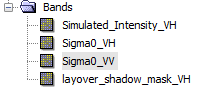
I want to remove the layover_shadow_mask from my area as I mentioned earlier…
But why layover_shadow_mask is in VH polarisation mode
can i use this to remove shadow from Sigma0_VV band ?