Crop monitoring and yield mapping with sentinel 1

you can start with the IR bands at first and if you see that they do not provide enough information for your analysis, sucessively entering more bands to the stack.

1 Like

okay i’ll try this thank you very much

Hello

Thank you sharing. We are trying to do same thing. I mean crop monitoring specially where sentinel-2 is not available (Cloud cover)

Kindly help me with the steps you followed to achieve this.

Regards
Shilpa R

you can start downloading a time-series of GRD products (same orbit) over one phenologic season and then investigate how different agricultural fields change regarding their backscatter.

Nice demonstration: https://earth.esa.int/workshops/ers97/papers/banyi/019c.htm

Also good tutorial: https://eo-college.org/resources/agriculture_tutorial/

Thank you @ABraun

We followed these steps.

  1. Downloading Sentinel-1 “IW-GRDH- VV+VH” product for our area of interest
  2. Using SNAP software we used tools like calibration, speckle filtering , Terrain correction, Linear to from db for data processing.

Don’t know how to proceed further on this.

I read article recommended by you. But I could not find how to extract backscatter value using SNAP software.

It would be helpful if you can suggest to find backscatter value and how to co-relate with the plot boundaries.

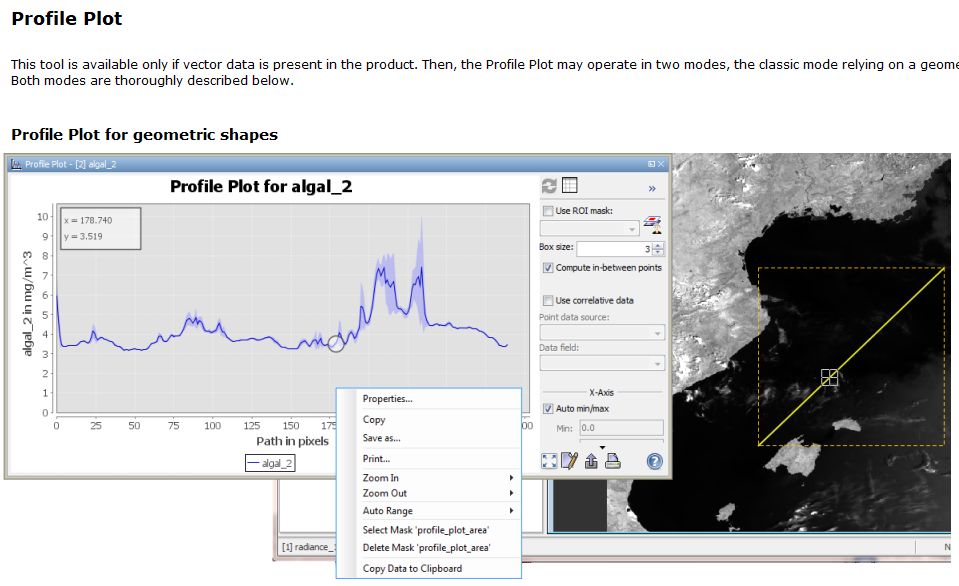
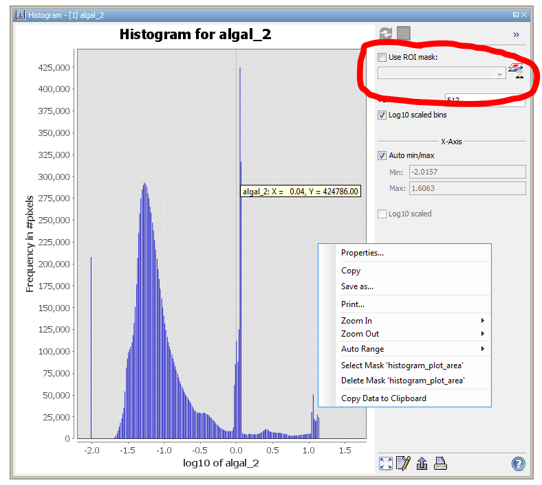
You can either use the profile plot to investigate the backscatter along a digitized line or the histogram tool to investigate the mean backscatter values within a digitized polygon (select ROI mask).

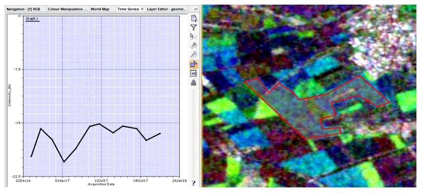
On the temporal scale, you can use the time-series tool which helps to investigate the temporal profile of a pixel, line or polygon:

Also see here: SAR Time-series Analysis tool"
and here: Time Series Analysis Tool - Possible Bug

If you have the plot boundaries as a shapefile, you can directly import it as a vector and use this instead.

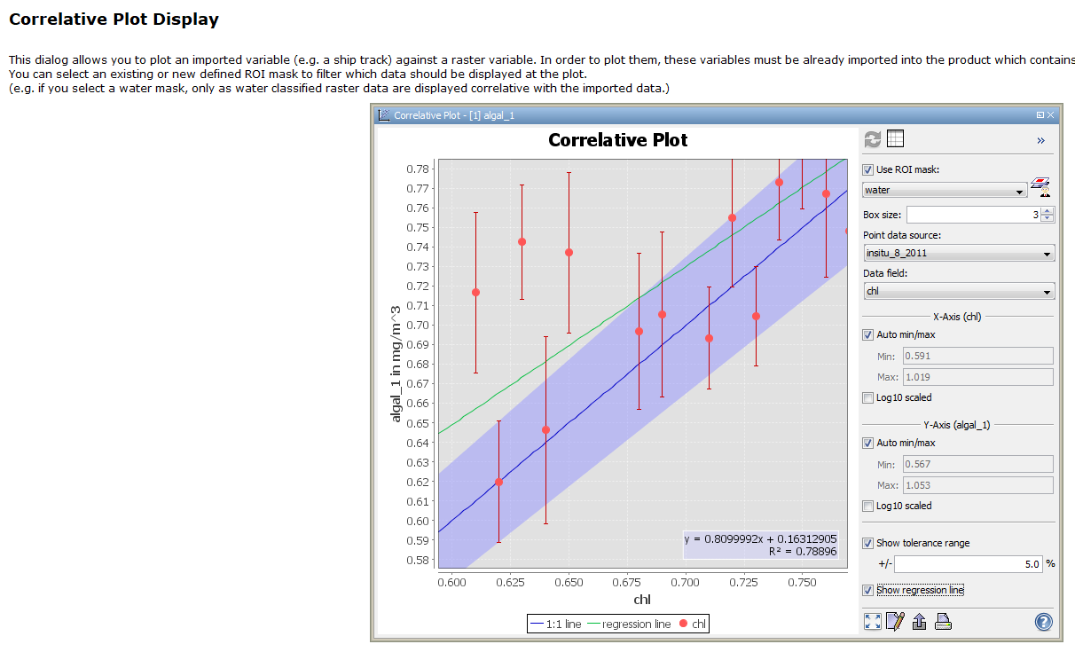
If you have already some attributes in your shapefile’s attribute table, you can use the correlative plot tool

Have a look at SNAP’s help section which explains the tools to you.

1 Like

Thank you @ABraun

Steps followed by us are

  1. Imported vector layer (Plot) using Layer Manager. (I didn’t find any other option to import polygon)
  2. We tried Time-series tool, But its showing back scattering value pixel by pixel.

How can I get avg/mean back scattering value for each plot?

This discussion might help you: SAR Time-series Analysis tool"

Thank You @ABraun

We tried Time-series analysis. We could extract back-scatter co-efficient values in csv formats.

Few of the challenges we are facing is

  1. Time series analysis takes only point data as pins. As co-efficient values are to that point, We are unable to get back-scatter values for polygon data. - Is it possible to import polygons directly and extract mean back-scatter value of the plots?

  2. How good it is to do work with SNAP software when we are dealing with thousands of polygon data?

  3. Actually we are dealing with Agriculture project, where we are suppose to give plot wise health status of the crop from SAR data. We have crop grown information available with us. - What is the right way to analyse and give crop health status?

Kindly suggest on these lines and help us to work towards it.

Yes, you simply import them as described here: Removing land by masking
I don’t know the performance limits of SNAP if you have large amounts of polygons. Do you want to have a plot for each of these thousands of polygons? Can you aggregate them by crop type (dissolve in a GIS)?

I would say, pin points are enough to get an information on vegetation health (NDVI) over a couple of growing seasons. If you can include polygons, even better.

Thank You @ABraun

When we tried to extract back- scatter value in time-series analysis its not reading any data imported in as vector layer. I have attached the screenshot below.

Each plot (Cadastre) is a polygon data. We have data for thousands of villages.

Indian region during Khariff season its difficult to get multi-spectral data for NDVI as it is monsoon season. So we have to relay on SAR data.

sorry, I cannot describe it any better than above.

Have you tried manually digitizing a polygon and see if it technically works?

Ok… If I have to put the question in different way…

I have export back-scatter co-efficient as csv option available only in Time series analysis. Time series analysis takes inputs from Pin manager. Pin manager has only option to import/create point data.

Is there any other way to give input as polygon to time-series analysis as i need to export co-efficient values? or any other tool is used to export back-scatter values (not as a graph, actual values) .

I still don’t get it. Time-series works on both pins and polygons and you can export it to whatever you want.#

Do you want a separate file with a mean backscatter value per polygon (and image date)?

You can use Zonal Statistics from QGIS for that.

2 Likes

@ABraun Thank you

Ya i need backscatter for each polygon. Will try in QGIS.

Is it correct method to use Geo-Tiff images to extract backscatter in QGIS? Earlier we used .dim format in SNAP to extract values.

no need for conversion to GeoTIFF, you can directly open the img files in the data folder of each product in QGIS.

@ABraun We got zonal statistics - (Mean) using QGIS but the values are in decimals like 0.0210, 0.0328… whereas we used to get -20, -15 back-scatter values form SNAP software. Why is this difference? We used Sigma0VH image. Are we missing anything?

db images are probably virtual only. You see this indicated by the v in the symbol of each band. Right-click your db images > convert band. Then File > Save product. They will then be physically written in your data folder as well and are available for use in QGIS.

@ABraun

We receive 2 strips for our project area, when we do SAR mosaic pixel values are changing from original to mosaic… How to solve this?

The process which we follow is

the reason for that is explained here: Alos 2 Geo-reference

1 Like