I have been working with SNAP and radar images Alos Palsar and Radarsat. My specific requirement for this is the work in wooded areas that allows me to indetify structures under it, but I have not found any example on how to use snap to penetrate the wooded layer.
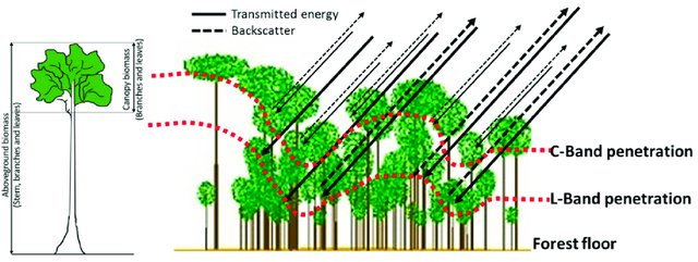
The ability to identify structures below the canopy is mostly limited (or enabled) by the wavelength and not necessarily a matter of application. L-band is partially able to penetrate volumes but I am not sure if signals would reach the ground. P-band would be more effective here, but the BIOMASS mission is launched in 2021 the earliest.
Yet, if you have fully polarimetric data you can apply a Pauli decomposition to highlight the different scattering mechanisms of a pixel. If there is something below the canopy it might give a different mixture in the RGB composition. An example is given here: ALOS-2 polarimetry
Thank you very much for the guide. When you refer to the quad-pol data do you refer to the 1.5 products?
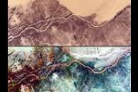
Another question, if I applied this in the desert, as I saw in some examples, it was found that I discovered paleo rivers in the nile. What recommendations or decompositions do you think would be appropriate for this type of analysis?
Greetings and many thanks for helping this simple student.
If you want to perform polarimetric decompositions you need Level 1.1. products because they contain the complex information of your signal.
Dry sand bodies often have variations regarding their volume scattering which is often the case for buried channels but most decompositions will highlight all three main scattering mechanisms (e.g. Pauli). More important is a large wavelength for highest penetration capability.