The reason is this:
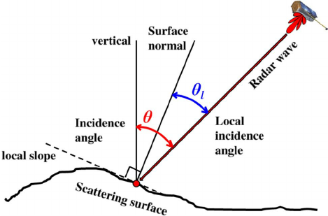
Beta0, also called radar brightness, is the basic calibration of a SAR product. It makes use of an internal calibration constant stored in the metadata. You use it if you don’t have information on the incidence angle (red angle) of your image. The incidence angle is defined as the angle between the surface vertical of the earth (without terrain) and the incoming signal.

Sigma0, the normalized radar cross-section, is an advanced measure of calibration. It takes into account the calibration constant and the incidence angle (which is mostly also known from the metadata).
But if you want to calibrate to Gamma0 which makes use of the local incidence angle (blue angle) you need to have a Digital Elevation model (DEM). The crucial point is that the Radiometric Terrain Flattening in SNAP is based on an algorithm by David Small (Flattening Gamma: Radiometric Terrain Correction for SAR Imagery | IEEE Journals & Magazine | IEEE Xplore) which does not use the (local) incidence angle but the area illuminated by the sensor of each pixel. Correcting for the angles before Terrain Flattening would kind of over-estimate the influence of surface orientation towards the sensor. Terrain Flattening therefore needs the basic calibration of Beta0 where the influence of incidence angle is still present.
* NOTE: Since SNAP 8, conversion to Beta0 prior to Terrain Flattening is no longer required, because it has been integrated into the TF operator.