The height-measurements are relative. If you know the height of a feature you can adjust the values to match that.
if you do not mind, can you explain a little bit.? relative in what sense. I know heights of some sample building, how should i match it. thanks for guidance.
The height-values are relatively correct meaning that the difference in height between two points is “correct”. For example for points A and B:
A = 23222m (from an arbitrary reference)
B= 23327m (from an arbitrary reference)
B - A = 105m (relatively correct height-difference)
1 Like
Need for phase unwrapping
The discontinuity of the extracted phase appears when an extreme value, or , is reached; the phase then jumps to the other end of the interval, or , even though physically the optical phase is continuous and relatively softly increasing or decreasing. As an example, let us consider a continuous phase proportional to a physical quantity (displacement, thickness, velocity…) varying linearly along a pixel row of the detector.
python
hi
I got this concept but can you tell me, how can i do this in software so all values changes accordingly.
waiting for answer
Thanking you
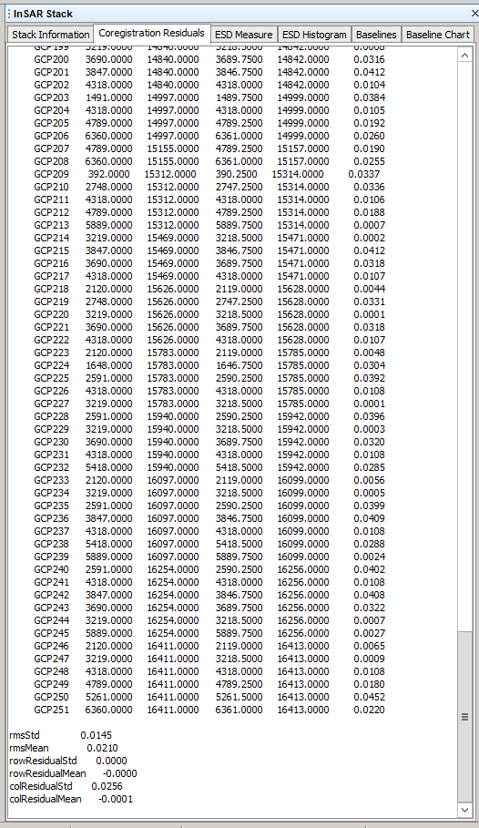
If I have to see the co-registration accuracy percentage or RMS Error in co-registration then is there any way for that in snap?
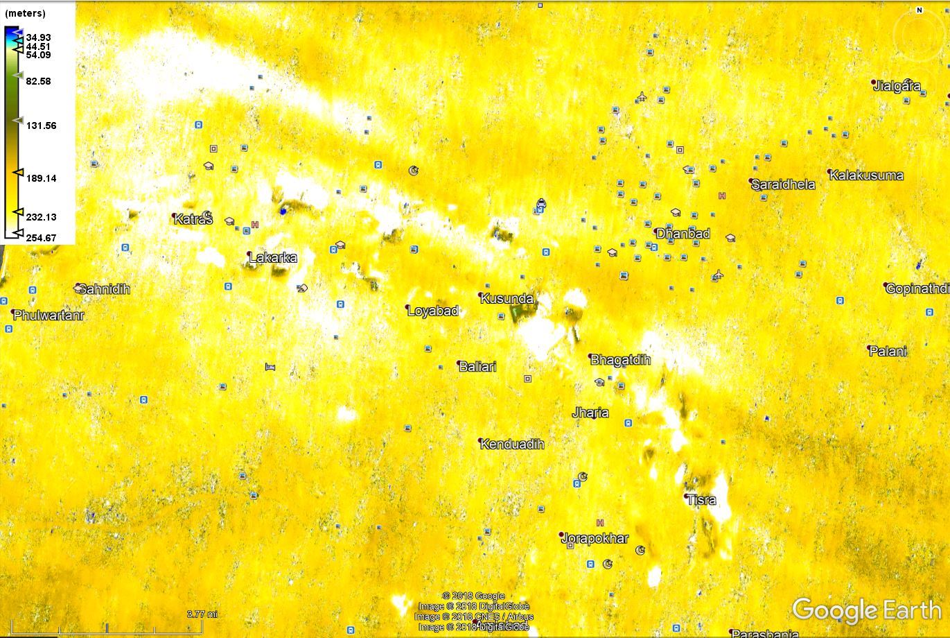
after following all step for land deformation I got the following results plz tell me
how can I get the accurate values for Elevation as well as Displacement Using the ground surey values of my study area . if possible tell me steps i have to follow in SNAP software for this.
thanks in advance

how do your inteferogram and your coherence look? Your image pair is probably not the most suitable and land cover is hindering proper phase retrieval.

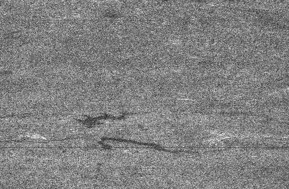
there is a pattern, but quite noisy. Did you apply multi-looking and filtering to the interferogram?
i applied filtering but not multi looking
and yes i did Subset also after Deburst
I don’t think that you can get better information that the freely available SRTM from S1 in this area.
thank you sir
these result showing relative height and displacement
how i will get absolute height and displacement (steps in software)?
I know the concept mentioned above that i have to give value to a point in map
but how ?
technically, you just use the “phase to elevation” module which uses a DEM as auxiliary informaiton to make absolute values. But influence of atmosphere, low quality areas in the interferogram and processing errors during the unwrapping add up to unrealistic results. The only option is to use different image pairs and compare.
The temporal baseline is just too high, I guess.
Images i used were of 14 and 26 jan 2018
So I think temporal baseline is correct ?
but again thank you for such a fast replies
now I will try on different data sets .
one last question you said these are the best possible result for that reason , why ?
yes, only same path acquisitions. INSAR / DINSAR - Perpendicular baseline calculation
Whether the sentinel-1 data is suitable for topographical studies?
Can building / feature height estimation be done by using this data?
Thanks
The spatial resolution of Sentinel-1 is not high enough for building heights.
Here is an example where elevation was successfully retrieved from Sentinel-1: The Order of DEM Creating Steps
But in many other cases, atmospheric conditions, low coherence and unsuitable perpendicular baselines are hindering good results.
Hey all,
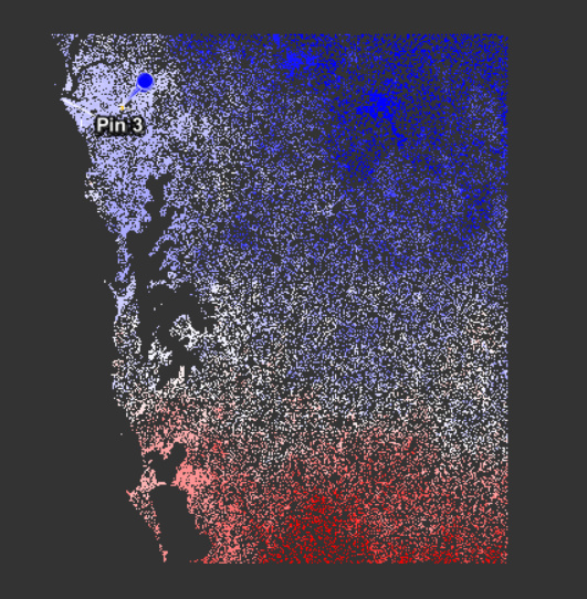
I know this probably isn’t a simple question but can anyone guide me to the potential errors illustrated here…
This is an XXXX_split_Orb_Stack_Ifg_Deb_ML_Flt_unwrapped - phase-to-displacement product (range -0.211m to 0.174m) and I have masked out the low coherence (<0.3).
Are the two extremes in this image likely to be caused from unwrapping errors, atmospheric or could it be DEM?
Any assistance would be greatly appreciated.
Kind regards,
JB