I want use S1A_SLC on date: 10/05.2019 but when Apply Orbit File is error.
So I download manual in https://qc.sentinel1.eo.esa.int/, but its not provided for this time.
precise orbits are provided about three weeks after the image acquisition.
Hi, I am really don’t understand to used GRD Product.
I using step: >>Multilooking >> Calibrate to Sigma0 >> Speckle Filter : Gamma Map >> Terrain Correction
But the intensity is contains many noise. What is the best step to find backscatter?
Regards
Multi-looking is not needed because GRD data is already range-detected.
If you don’t need the comparably high spatial resolution of 10 meters, you can still multi-look your data to downsample it a lower spatial resolution (e.g. 60 meters) with to enhance your image quality.
If you need 10 m of spatial resolution, the best choice to reduce speckle is to test and compare different filter types.
Thanks you Sir, I think multilooking is similar with Thermal Noise Removal. I will do this step:
But in thermal noise removal is error. And I really don’t know to fix this.
Are you have simple solution to fix this Sir?
Are you sure that all updates are installed? Check under Menu > Help > Check For Updates.
How about this sir?
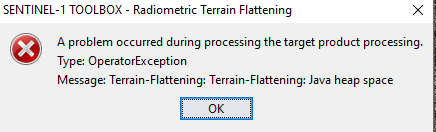
yoour computer ran out of memory. How much RAM is installed?
My RAM Computer is 8 GB
it is possilble that it was not enough for this task. Can you make a smaller subset of your data or do you need the whole region?
Oke sir, I can make a smaller subset
Hello Sir, Now i have correlative plot 87 and 81
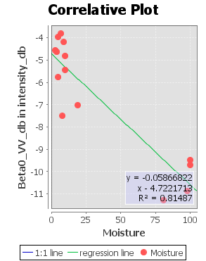
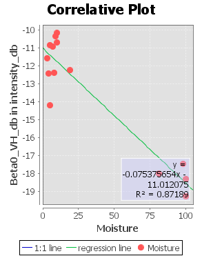
But my step is:
calibrate to Beta0>Speckle filter (lee Sigma) >> Linear ToFrom dB>> Terrain Correction. this is true step?
So you skipped Terrain Flattening this time?
This is fine, but you can then directly use Sigma0 (slightly higher level of calibration than Beta0). But it probably won’t make a large difference for the pixel values…
Yes sir, I skip Terrain Flattening because I am not yet try to subset data. I will try this step sir
Calibration always gives out Sigma0 as well, simply use it in the soeckle filter and recompute the plots.
Hello Sir, can you help me to find a way make an image like this:
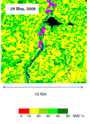
but I make it from backscatter of Sentinel-1A GRD.
Btw, I have csv file of backscatter each pixel
Regards
I have no idea how this was generated, sorry.
Modelling soil moisture by SAR data is not an easy task to be honest. You mostly need multi-temporal data and lots of measurements. And even if this is given, factors such as roughness and vegetation cover play an additional role.
Thank you Sir
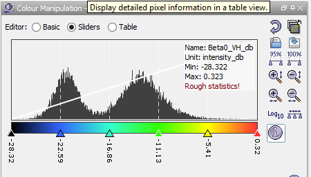
Can I using Color Manipulation like this Sir?
And I find Soil Moisture Mapping like this:
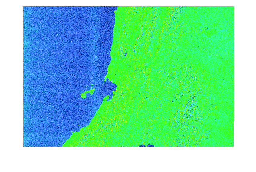
This Color will change based on intensity.
Regards
you can use the color manipulation to identify areas of different backscatter intensity. But as I said, backscattering consists of roughness, moisture, material and surface cover.
From a single image you cannot tell if low backscatter is caused by the smooth surface, low moisture content or another factor.