Some smaller issues

I have noticed some minor things which I list below. None of them are urgent but maybe they can be fixed some day :

  1. When you rename a band, a new raster is written in the data folder but the original raster remains. Wouldn’t it make more sense if only the renamed one remains? This is of special importance with larger data.
  2. If you close a product and there were changes you are asked if you want to save. If you click ‘yes’ the changes are written but the product is not closed afterwards. At least sometimes. I can’t find a pattern here.
  3. Would be nice multiple products could be saved with one click. Currently only one product can be saved at one time. If #2 could be fixed, you could save them all by close multiple products at once. At the moment, if you close multiple products with changes, only the first one is saved, even if you click ‘yes’ for each product.
  4. The Linear to/from dB operator doesn’t work in batch mode. After the first product was processed by the graph, the input for the operator remains, thus being not found in the subsequent product.
  5. Renaming multiple bands with the same name is possible through the properties menu, but after saving, these products are corrupted and can no longer be opened in SNAP.
  6. seems that orbit and track and acquisition data are no longer shown in the first tab of the coregistration tool. Tested on S1, Envisat and ERS data. Edit: Solved here.

Thanks a lot for this compilation.
I’ve turned them into issues for our issue tracker.

Regarding #5.
Can you tell how you have renamed them? Simply by the properties dialog or was it done by a tool?

thank you for the reply. I renamed them by right-clicking > properties and edited the name there and saved the product. Is there another way to do it?

Ha, now I see. You actually wrote it already. Sorry, overlooked it.
No, this is the right way. But some tools rename the bands too. That’s why I was asking.
Is no error message shown?
I just tried it on a S2 MSI images and it worked. So I wonder which product you have used. Maybe it has some speciality?

it is actually just Sentinel-1 data which I renamed after calibration from
Sigma0
to
S1_201701014_VV
for example. Yet, the Sigma0 raster remains.

Luis commented the issue regarding the coregistration:

This was done on purpose. It takes considerable time to read the products and retrieve the information when there is a long list of products.
There is the refresh button which can populate the information.
Some UX work could be done to inform the user that the information could be populated on request.

oh I never saw the refresh button…

Consider it done in this case :smiley:

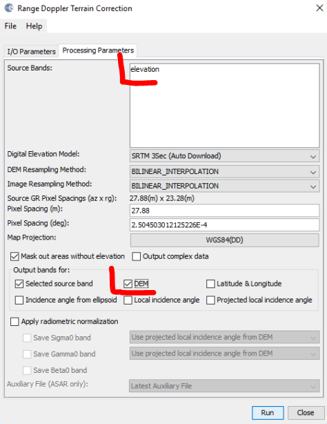
I just use this topic for another suggestion:

In the Terrain Correction step, there is the option to put the used DEM in the output product as well, which I consider useful for many cases. However, as it is just named “elevation”, it is repeatedly being misunderstood as the elevation information extracted from radar interferometry. Here, TC is the last step to be applied and the output contains
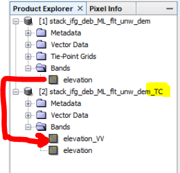
elevation_VV (renamed from the elevation generated by the “phase to elevation” module) and elevation (as additionally written from the Range Doppler Terrain Correction).


grafik

One solution would be to name one of these bands more clearly:

  • can the DEM used for Range Doppler Terrain Correction be named after its source? e.g. SRTM, ASTER, ACE30 or external_DEM?
  • can the output of “phase_to_elevation” be named different - e.g. InSAR_elevation (or something similar)?

The first option would be the more clear, the other probably easier to realize.

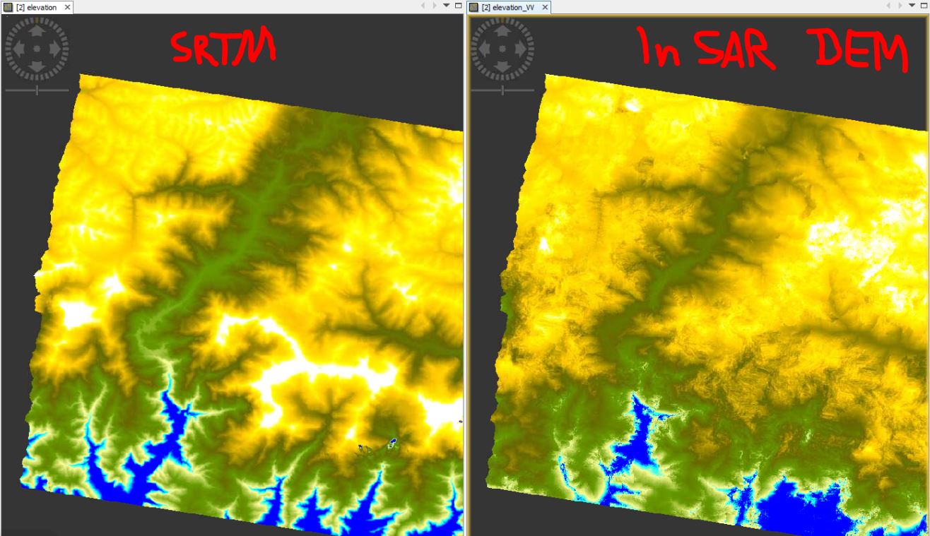
Two examples where the SRTM elevation is falseley understood as the InSAR result:

I don’t know where this idea comes from, maybe an unclear tutorial. An experienced user wouldn’t struggle with it but it would increase understanding of the difference of both products.

5 Likes