it means that its already ground-range corrected. Unlike SLC data the pixels’ areas are already of same size.
Astrium has made nice graphics for this case. They refer to TerraSAR-X but the principle is the same for most SAR satellites:
Slant Range Complex (SLC/SSC/L.1.1)
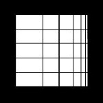
Data is neither multi-looked nor projected
Ground Range Detected (GRD/MGD/L1.5)
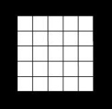
Data is multi-looked but not projected
Geocoded Ellipsoid Corrected (GEC/L2.0)
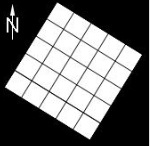
Data is projected but topographic distortions are still in the product.
EEC -Enhanced Ellipsoid Corrected (EEC/GTC/L2.1)
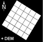
Data is projected and geometric distortions caused by the terrain have been removed by a DEM.