I have three SLC datas : S1A_IW_SLC__1SDV_20181006T115432_20181006T115459_024015_029FB2_E498 S1A_IW_SLC__1SDV_20190122T115430_20190122T115457_025590_02D70C_4EC1 S1A_IW_SLC__1SDV_20190323T115429_20190323T115456_026465_02F6A8_D073
In terms of local incident angles and elevations,I want to study: 1.The variation of backscattering coefficients in different periods 2.The variation of polarization parameters obtained by h/a decomposition in different periods
My questions:
1.Coregistration and Multi-tempol speckle filtering.Are they necessary?
2.Multilook.Is there a difference between the looks 1:4(calculated) and 1:5(ESA)?
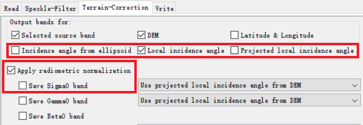
3.Terrain Correction. a.output bands:To get the local incident Angle, which one should I choose?Incidence angle from ellipsoid,Local incidence angle or Projected local incidence angle? b.radiometric normalization:Is it necessary for my research?And when I select “save Sigma0 band” ,it does not work?
Especially if you want to compare images of different dates, multi-temporal speckle filtering is not a good idea. It wouldn’t be effective on three images either.
Coregistration only makes sense to me if you want to compare single pixels for their properties. For general scatter plots (e.g. incidence angle vs. Sigma0), this is not required.
If you want to compare backscattering coefficients (your first workflow), the normalization is no longer required. It is kind of a relic from earlier versions (see lveci’s answer here)
If you want to correct radiometric errors caused by topography, you should run Terrain Flattening (as suggested here), but its results strongly depends on the used DEM.
I would select the SRTM 1 Sec for the Terrain Correction because of its higher spatial resolution.
It is best to derive the polarimetric parameters from undisturbed (non-interpolated) values and to co-register at a later stage if necessary. Multilooking destroys information so it should be done later also if necessary.
Thank you for your answer! I am new to this field, and I still have a question.Since my research object is snow cover in mountainous areas, I want to study the effect of local incident Angle and elevation on its backscattering coefficient.If I run Terrain Flattening, is that the same as removing the terrain?And I can’t study the effect of elevation on it?
if you want to study the effect of the local incidence angle (topography), you skip the terrain flattening and simply convert to Sigma0 (corrects for the global incidence angle).
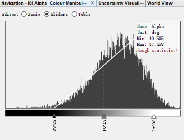
Such as water,the main scattering mechanism should be surface scattering,so it should have a smaller α value.But it’s actually over 40°.Exactly the α value of the whole image is relatively large.Maybe there’s something wrong with my process?
the derivation of scattering mechanisms is not very reliable from the dual-polarized Sentinel-1 data (VV/VH). To extract precise proportions of surface, dihedral, and volume scattering, you need quad-pol data.
You can still use Sentinel-1 to get first indications and detect differences between surfaces, but I would not refer to value thresholds which were empirically tested on quad-pol data.
So the results of H/α decomposition in SNAP and Polsarpro are same?and if I want to determine the scattering mechanism based on the α value, I can only use quad-pol data?
SNAP and PolSARpro should lead to the same results. The question is how much they help you. It was discussed here, to what extent dual-pol data can be used as input for Ha decompositions.