Dear all,
Could anyone here share me a tutorial how to process Sentinel-2 data ?
I prefer to have a written tutorial , not video??
Thanks
Dear all,
Could anyone here share me a tutorial how to process Sentinel-2 data ?
I prefer to have a written tutorial , not video??
Thanks
The general way of processing is independent of the sensor.
If you want to do bulk processing on the command line you can have a look at these two pages:
If you want to do processing in the desktop application, I only know the videos.
Sentinel-2 data is nearly ready to use, my question is what you undestand of ‘processing’ and what you want to do with the images.
Dear Jigme Tenzin,
In the frame of the ESA Land Training Course 2018, I have generated a tutorial in PDF to calculate water change (based on NDWI2) and forest change (based on NBR) detection using Sentinel-2 data.
In this document is explained how to open a S2 product, how apply BandMath and how to generate a Graph.
The document for the moment is freely available at http://eoscience.esa.int/landtraining2018/files/materials/D2B4_ESA-LTC2018-Practical_day2_RAMOINO.pdf but I will upload soon on STEP Tutorial section.
Best Regards,
Fabrizio
Thank you very much.
Basically I am trying to apply radiometric and geometric correction to Sentinel -2 L1C product using SNAP. I am not sure do I really need to calibrate radiometrically like we do in LandSAT ?
Since my study area is a mountainous region, so we need to apply topographical correction using DEM? I am confused how do we validate the correction is applied ?
From your statement, what I understood is that we dont need to apply those sort of corrections?
Thank you very much for sharing the documents.
Do we need to apply radiometric ( radiometric calibration and atmospheric correction) and geometric for Sentinel- 2 to be used for LULC mapping?
Kindly enlighten on these two correction , please?
If available, you can download L2A products which are already radiometrically corrected.
sen2cor uses a DEM to reduce topographically induced radiometric distortions. The geometric accuracy of Sentinel-2 is quite fine, no orthorectification is usually needed.
Here you can read about the geometric quality requirements: https://earth.esa.int/web/sentinel/technical-guides/sentinel-2-msi/performance
You can also have a look at the chapter “4 Anomalies” in the S2 Data quality report: https://sentinel.esa.int/documents/247904/685211/Sentinel-2_L1C_Data_Quality_Report
It lists which orbits and products are affected by geolocation errors.
Dear Fabrizio_Ramoino,
Your tutorial in PDF format is of great valuable. Thank you very much!
I hope more PDF tutorials and algorithm ATBDs can share in this forum.
Big thanks and looking forward to interact more.
i’m working on level1C of sentinel-2 and i have to apply atmospheric correction in order to obtain level 2A and to compare this with level2A available on the site of ESA. The problem is that the values do not coincide. WHY?
maybe one of the answers given here help you: Different colors in L2A images
If not, feel free to describe your problem in that topic, ideally with examples on how much the values differ.
Hello @Rosellina
Maybe the differences here contribute?
http://step.esa.int/main/third-party-plugins-2/sen2cor/sen2cor_v2-8/
It is important to know, that the default configuration of the L2A algorithm provided with Sen2Cor version 2.8 is the same configuration as for the L2A “Core” Products processing in Sentinel-2 Ground Segment with L2A processing baseline 02.12. Therefore, no further tuning should be required on user side to get L2A Core Products. In order to generate products compatible with the L2A Core Products it is necessary to set the usage of a Digital Elevation Model to improve Scene Classification and have the activation of ESA-CCI data-package to be downloaded here and installed. The usage of ESA CCI data package for Sen2Cor v2.8 is detailed in the dedicated Software User Manual: S2-PDGS-MPC-L2A-SUM-V2.8.
The only differences between “L2A Toolbox” and L2A Core Products are reported in the following table:
| Category of Difference | Difference | L2A Toolbox | L2A Core Products |
|---|---|---|---|
| Product Format | HTML Folder | No | Yes |
| Manifest | Same Set of Items but arranged in different order | ||
| Product Quality Metadata | Copied from L1C | Generated by L2A On-line Quality Check (OLQC) | |
| Radiometry at Pixel Level | Digital Elevation Model | e.g. SRTM/DEM defined by the users | PlanetDEM |
| JPEG2000 encoding library | Kakadu | OpenJPEG |
Cheers
Jan
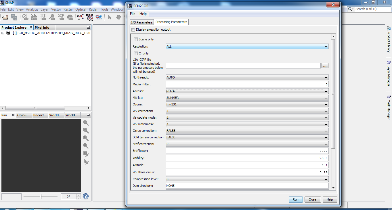
After processing with sen2cor, with ALL resolution, the reflectance values of the pixels in the data obtained 2A do not correspond to the value of the data 2A downloaded directly from the copernicus site. how is this possible?
can you please show an example where the values are different?
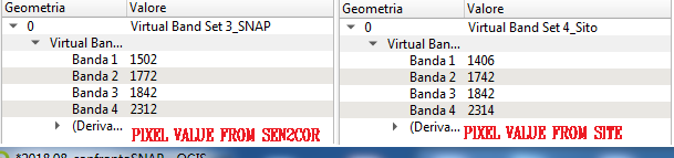
have you used the DEM and activated the ESA-CCI data package as suggested by Jan?
not yet. the pc is slow and i’m trying to do it right now.
I’m very in total difficulty. I read all the documents, I downloaded ESA-CCI data package but the problem is, at this point, how to set these parameters.
As a note, you can’t get exactly the same values as in the official L2A products. When you run sen2cor you are using a different DEM. The DEM which is used in the ground segment is not officially available.
And the differences you experience are less than 0.01 (0.1502 <–> 0.1406). The values you show in the image are just the raw counts. They need to be divided by 10000 to have the reflectance values.
So, it might be already the accuracy you can achieve.