INSAR / DINSAR - Perpendicular baseline calculation

I’m not sure, could it be the order master-slave vs slave-master?

Hello,
i would like to know how to find the master image among the slave images through the perpendicular baseline

2 Likes

Hello everyone, as far as I know,
to create DEM : Bperp value should be <300m
to determine deformation: Bperp value should be <100m . If I’m wrong, correct me please. But my Bperp value is very high always? for example, 1218519.58 :hushed: that’s really too much.
What could be the reason?
Thanking you in advance.

1 Like

you need to have data from the same path (also called track).

1 Like

Thanks dear Andreas. But, could you explain more clearly? Sorry, I could not understand. What should I do? What should I pay attention to downloading data? Thanking you in advance.

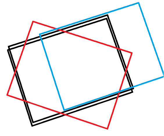
when you download your data, make sure that both data sets cover the same area, in particular in West-East direction and flight direction. So for interferometry, you cannot combine ascending and descending images, nor images from different tracks
For Sentinel-1, for example, these dates are multiples of 6 days, so 6, 12, 18, 24…

So, in my example, you can use the two black images, but not black with red or black with blue

10 Likes

@ABraun Thank you for this wonderful answer. I will consciously try again. :slight_smile:

Dear ABraun

My Sentinel -SLC data are for the same path and frame but
one of them is containing the another like the attached pic. Is it status good for interferometric analysis specifically subsidence. What about other properties (Perpendicular BaseLine )
I welcomed for any suggestion.

Regard

Dear @Meelad_16777,

All Sentinel-1 products belonging to the same track are suitable for interferometry (with intrinsic coherence loss due to temporal baselines) , as the Sentinel-1 mission was specifically designed to have its orbit is controlled within a orbital tube which makes this possible.

If one product is contained inside another might be due to the number of burst contained on each of the images.

I hope this helps.
Cheers,

1 Like

Dear @mdelgado
Fortunately I got two Sentinel-1 granules (A, B) with different temporal time. I need more detail about Perpendicular Baseline what is the suitable distance between the different acquisitions of Sentinel data that help Land Subsidence researches. So I knew from the Step Forum here that the interferometric technique required coherence in properties such (Polarization, Farme & Path, Direction Dsc\Asc, and Beam Mode ) between the granules used in Monitoring , if I don’t wrong for good desciplacement results.

Thank you for great help.

Cheers.

For land subsidence research… you have to take into consideration the critical perpendicular baseline, for which if your baseline is higher, the coherence is zero and then no information can be retrieved from the interferometric phase.

However, Sentinel-1 mission was designed to keep all possible baselines inside the same track suitable for any InSAR study (single event such Earthquakes, or multi-temporal analysis using PSI/SBAS/etc…)

So you can proceed processing each image pair S1-A/B from the same track, with the convintion to get interferometric products from it. Obviously, the higher the temporal baseline, the lower the coherence, as normally temporal decorrelation start to make a role when you get large temporal separation between master and slave.

Good luck and let us know

5 Likes

After Coregistration,Is the screenshot suit for inSAR?

1 Like

yes, now you know that your satellites were 46.23 m apart when taking their images.

Do you know if that operator can be called also via got/command line?

if I remember correctly, this has not been possible so far.

Because it would be a very welcome feature to have, already in SNAP 7 or 8.

Is this possible? @marpet @lveci

For 7 rather not because we are currently working on v 8 however could be requested for future versions

1 Like

Dear ABraun
my Intensity SLV file missing in stack after coregistration,I have chosen the interferogram as required, but the result is still the same,what should I do? thank you in advance

I recommend to reduce the bursts of both inputs so that the same bursts are covered in a first step. Then orbit files and back geocoding.

sorry,could you tell me how to achieve reduce the burst,thank you.I try to subset,but it does’t work.